|
|
Post by dsquaredmsquared on May 5, 2010 21:15:01 GMT -5
Here is a shortened URL for FATS - showing the North (Tower and Big Rock) and South parking lots. bit.ly/c0Us2x Also shown, is a connector that you can ride from Deep Step to Tower/BigRock. |
|
|
|
Post by dsquaredmsquared on May 5, 2010 11:03:17 GMT -5
Here is a shortened URL to a Google map of Bartram Trail and parking areas. bit.ly/aIhMCA |
|
|
|
Post by dsquaredmsquared on May 1, 2010 12:57:19 GMT -5
After Modoc with JT, I took care of the standing water on GW. First picture is from Tuesday and the 2nd is the clay hole looking better.   Thanks to the person(s) who trimmed the branches off the overhanging tree. |
|
|
|
Post by dsquaredmsquared on Apr 28, 2010 8:45:26 GMT -5
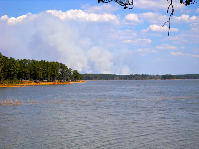
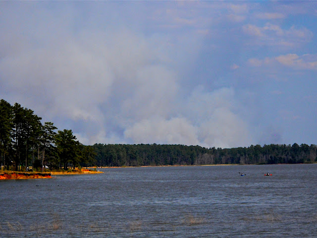
Rode Great Wall yesterday afternoon. The weather was cool, windy, and there were a few sprinkles here and there. Except for one spot of standing water, the trail was nice and dry. I'll try to take care of that puddle this weekend. I also came upon two downed trees/trail features - not sure which. One was a large log, with the broken end sticking halfway into the the trail. I managed to move it a bit, so it is less in the trail, but couldn't muscle it completely off the trail (sorry if it was meant to be there).   The other downed tree hangs over the trail. It's a low bridge that I barely made it under, but there are branches that could be trimmed. However, and just off the trail, the overhanging tree is is mixed up with at least one other downed tree. If this needs to be cut down, I'd be happy to help.   Lastly, saw a double rainbow on the way home. One end of the rainbow(s) was in Martinez and the other end looked like it was in FATS.  Here is a map showing the downed trees/trail features. 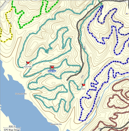 I will try to take care of the puddle on Saturday afternoon, or morning if it rains, and would be happy to help out with the trees - if they need to come down. David |
|
|
|
Post by dsquaredmsquared on Apr 17, 2010 17:45:35 GMT -5
Last Sunday, Ben was riding that SUPER tight radius, steep berm. He rode it ccw and I noticed that he was lifting his front wheel, dropping it to the inside, as he came off the last few feet of the berm (and onto the first table-top). It was pretty cool watching him ride  |
|
|
|
Post by dsquaredmsquared on Apr 14, 2010 9:09:32 GMT -5
She was there last night ~5:00PM. Walks up to within 5ft. of you, looks at you for a few minutes, and then wanders on. The last 3-5 times I was at FATS I saw her entering/leaving the wooded strip between the two parking areas. I only had chocolate with me so I didn't give her anything.
|
|
|
|
Post by dsquaredmsquared on Apr 12, 2010 20:47:19 GMT -5
|
|
|
|
Post by dsquaredmsquared on Apr 12, 2010 12:07:22 GMT -5
Yeah it is Didn't do any tool work but rode it in some on Sunday. Having never seen or ridden one before, it wasn't as easy as it looks. Legs are still burning a little. Can't wait to get out there again and practice. |
|
|
|
Post by dsquaredmsquared on Apr 3, 2010 15:55:40 GMT -5
Jumper780,
Although your Garmin 405CX doesn't seem to do barometric altitude, you can (attempt to) correct for GPS altitude by enabling "altitude correction" on the Garmin Connect site (lower left corner, where it shows your device).
It looks like the correction is enabled for your ride today, but not enabled for your previous ride (with the exaggerated elevation gain). You might get a more realistic elevation gain if you enable that correction for your previous ride.
D.
Edit: If I download your Sunday ride data as GPX file, then re-upload to Garmin Connect, and enable error correction I get ~853 ft. of elevation gain for your Sunday ride (and it does not have you riding below sea level). Hope this is helpful.
|
|
|
|
Post by dsquaredmsquared on Mar 27, 2010 15:53:03 GMT -5
Sweet pictures. Gotta get out there before everything grows back.
|
|
|
|
Post by dsquaredmsquared on Mar 21, 2010 11:56:48 GMT -5
|
|
|
|
Post by dsquaredmsquared on Mar 18, 2010 19:56:28 GMT -5
Yes, it opened this week (technically, last Friday). I rode into work, from the head gates, on Monday AM and the fence is gone.
|
|
|
|
Post by dsquaredmsquared on Mar 1, 2010 10:24:49 GMT -5
Forgive me, I am weak. I rode Brown Wave Sunday.  On the upside, I was able to see the longer term consequences of quick & dirty drain cleaning (i.e., narrow channels; many of them mine) versus the longer-lasting method of wider, more bowl-shaped sculpting of the drainage area. Long story short, I need to go back with the correct tools and redeem myself. The problem drainage areas, with narrow cut channels, were still soft and you could already see tire tracks building up the down slope (correct term?) side. Also, saw the scouts out there blazing trees on BW. Excellent job. |
|
|
|
Post by dsquaredmsquared on Feb 26, 2010 12:08:10 GMT -5
So, with that segue...any organized work party for Sunday? If not, then I may finish drain cleaning on the lower loop of BW.
|
|
|
|
Post by dsquaredmsquared on Feb 24, 2010 18:16:59 GMT -5
You learn something new every day, thanks.
|
|
|
|
Post by dsquaredmsquared on Feb 24, 2010 16:41:48 GMT -5
The doctor lets you do it at home?
Every other week I have to haul over to the allergy clinic for my 2 shots in each arm (4 vials total). The first 6 years down here were fine and then, in the 7th year,...bam! Oh yeah, the Rx Allegra helps too.
|
|
|
|
Post by dsquaredmsquared on Feb 13, 2010 7:56:41 GMT -5
Nice wet snow last night and we had neighborhood snowball fight. Snow is too dry now for snowman  Can't even join you and BW for a ride; we're not going anywhere fast. Neighbor's tree went through their fence and across our driveway. |
|
|
|
Post by dsquaredmsquared on Feb 12, 2010 20:46:17 GMT -5
Ha...I'm out too. With all this snow, I have snowman duty tomorrow AM. I would be glad to help out with trail work on Sunday AM.
|
|
|
|
Post by dsquaredmsquared on Feb 9, 2010 20:19:32 GMT -5
I'll try to join you Saturday morning.
|
|
|
|
Map
Feb 4, 2010 13:06:10 GMT -5
Post by dsquaredmsquared on Feb 4, 2010 13:06:10 GMT -5
Ahhh. So... the trail intersection/direction sign posts, emergency access/egress sign posts, and other scattered landmarks (rock gardens, notable trees, bridges) might be useful as locator points on a map.
|
|