|
|
Map
Feb 2, 2010 8:52:53 GMT -5
Post by dgaddis1 on Feb 2, 2010 8:52:53 GMT -5
Here's a MUCH better map of the Boyd Pond trail than what is currently on the website. This is the map that will go on the new website, with a few additions/modifications. (look for the new website to go live this month!) This is courtesy of Ben D. and his Garmin GPS. It shows two laps...I think I can edit the raw file to just how 1 lap for the final map. This trail is pretty dang twisty. 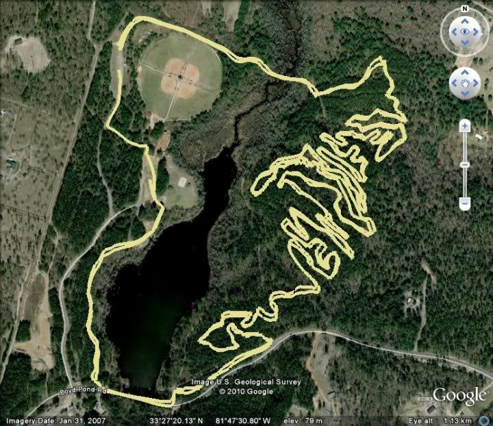 (...I gotta get me a gps......) |
|
|
|
Map
Feb 2, 2010 10:16:52 GMT -5
Post by dsquaredmsquared on Feb 2, 2010 10:16:52 GMT -5
I brought my GPS last week and only did one lap (although it is easy to change the data to show one lap). Here is a tinyURL link to Google Maps < tinyurl.com/ylogr5j Hope this is helpful. David |
|
|
|
Map
Feb 2, 2010 10:26:47 GMT -5
Post by dgaddis1 on Feb 2, 2010 10:26:47 GMT -5
YES.
What other trails do you have?
|
|
|
|
Map
Feb 2, 2010 10:29:54 GMT -5
Post by dgaddis1 on Feb 2, 2010 10:29:54 GMT -5
Also, do you have any info on the elevation? Can you upload your info to either Motion Based or Garmin Connect?
|
|
|
|
Map
Feb 2, 2010 10:31:24 GMT -5
Post by dsquaredmsquared on Feb 2, 2010 10:31:24 GMT -5
Here is a link to the trails I've ridden with GPS. tinyurl.com/yfm5u7yFATS (6 loops + connectors) Bartram Keg Boyd Pond Maybe Hickory Knob on Saturday. |
|
|
|
Map
Feb 2, 2010 10:35:30 GMT -5
Post by dsquaredmsquared on Feb 2, 2010 10:35:30 GMT -5
Yes.  If you prefer, I can have an image of just the elevation profile. All my GPS information is in Garmin GPX format. Using GPSbabel (on a mac) I can change GPX to KML, KMZ, and a ton of other formats. I think you need a Garmin Edge-like GPS to upload to Garmin training center. Not sure about Garmin Connect or Motion Based. Will try this afternoon or this evening and let you know. |
|
|
|
Map
Feb 2, 2010 10:41:21 GMT -5
Post by dgaddis1 on Feb 2, 2010 10:41:21 GMT -5
I'm very excited right now.
You'd be the coolest guy ever if you could send me a jpg (largest size you can) of the elevation profile of every loop you've ridden. Please include the direction the trail was ridden, as well as the start/finish locations, and the total climbing.
For FATS, I'd like one of all six loops, and one of each individual loop. If you could add markers to the elevation profiles showing where it is (turn onto Deep Step Rd, Turn onto Philpot Rd, Turn onto Big Rock CCW, etc) that'd be AWESOME.
I really want an Edge 705......they sure want a lot of $$ for them though.
|
|
|
|
Map
Feb 2, 2010 10:53:57 GMT -5
Post by dsquaredmsquared on Feb 2, 2010 10:53:57 GMT -5
Give me a day or two and let's see what we can do.
I don't have an Edge. I have the GPSmap 60csx, which is a hand held unit we use for geocaching (BV has a similar model and may have data for trails that I haven't ridden). It has a fantastic antenna and holds on to satellites really well - even under pretty dense canopy. I ride with it in the outside pocket of my camelbak.
David
|
|
|
|
Map
Feb 2, 2010 11:03:38 GMT -5
Post by dgaddis1 on Feb 2, 2010 11:03:38 GMT -5
Cool - thanks. It's no rush.
I've heard very good things about the 60csx.
|
|
|
|
Map
Feb 2, 2010 22:29:40 GMT -5
Post by dparrott on Feb 2, 2010 22:29:40 GMT -5
The Keg map is the most up-to-date with all current mods - looks great. Remember that GPS distances show "true horizontal" distance, not actual ridden distance. Most accurate is a measuring wheel but if you calibrate your bike computer to the actual measured circumference of the tire, you're there.
|
|
|
|
Map
Feb 3, 2010 7:15:25 GMT -5
Post by dgaddis1 on Feb 3, 2010 7:15:25 GMT -5
Are you sure they just measure horizontal distance? They know your elevation, so it's easy for them to calculate the actual distance between two data points.
I know they "round off" the corners, so that will cause the distance to come up a little short.
|
|
|
|
Map
Feb 3, 2010 8:37:50 GMT -5
Post by imnav8r on Feb 3, 2010 8:37:50 GMT -5
Now that is a great map!!
Thanks David!
|
|
|
|
Map
Feb 3, 2010 10:53:28 GMT -5
Post by dsquaredmsquared on Feb 3, 2010 10:53:28 GMT -5
Dustin: Here is an annotated elevation profile for Big Rock and Tower. Is this what you want? Comments, corrections, suggestions are welcome.  |
|
|
|
Map
Feb 3, 2010 11:25:33 GMT -5
Post by dsquaredmsquared on Feb 3, 2010 11:25:33 GMT -5
If you're going to go with this, I think this version may be more useful to the new people at FATS.  |
|
|
|
Map
Feb 3, 2010 11:39:11 GMT -5
Post by imnav8r on Feb 3, 2010 11:39:11 GMT -5
Dustin and or/David can you guys get a copy of the FATS, Canal, and Bartram GPS maps to Liz Victor?
She is looking for our area trail maps to give to IMBA for the purpose of IMBA creating some sort of trail map package for the Summit.
I sent her what I have, but those maps aren't as good as these.
If you have more maps available, I'm sure she'd appreciate it. Her email address is lizvic29 at aol dot com.
Thanks!
|
|
|
|
Map
Feb 3, 2010 12:14:26 GMT -5
Post by Timothyjames on Feb 3, 2010 12:14:26 GMT -5
Once i'm out riding again i'll be mapping with my garmin305. Cadence sensor is hooked up to my road bike right now so It'll be weather dependent. Gotta love some ORA!
|
|
|
|
Map
Feb 3, 2010 14:00:49 GMT -5
Post by dgaddis1 on Feb 3, 2010 14:00:49 GMT -5
If you're going to go with this, I think this version may be more useful to the new people at FATS. That looks pretty good...only problem is I don't want to put #'s on a map because people may think it's location markers or mile makers. Also, the numbers on the elevation profile's axis (elevation and distance) need to be larger so when the whole thing gets scaled down they're still readable. How about this, instead of putting all those markers on it (it gets kinda busy) we could just put some text at the bottom that tells the starting/ending location and direction. So for this one, it would say "From North Parking Lot ride CCW on Big Rock to CCW on Tower, finish Big Rock CCW back to North Parking Lot" I can add the text if you want. (doesn't bother me if you do it though!) |
|
|
|
Map
Feb 3, 2010 15:16:26 GMT -5
Post by EdgeE on Feb 3, 2010 15:16:26 GMT -5
I like some kind of key/locator on the elevation profile. The above is nice, it ties the trail map & elevation together. Maybe use some geometeric symbols rather than #s or letters to tie them together. Seeing the location of 4 on the map & on the profile, I doubt I'll ever take that turn w/o thinking here we go. Without something to tie the elevations to specific places on the trail I would have never known that was the spot. Sure, I would know how much elevation change there was, but its hard to tie the linear nature of the graph to a specific spot on the trail w/o something.
Just my $.02
|
|
|
|
Map
Feb 3, 2010 15:21:34 GMT -5
Post by dgaddis1 on Feb 3, 2010 15:21:34 GMT -5
I agree. Just dont want to clutter things up.
What if we put the labels along the x-axis (distance)?
|
|
|
|
Map
Feb 3, 2010 15:28:04 GMT -5
Post by EdgeE on Feb 3, 2010 15:28:04 GMT -5
That would work for the graph, but what about the map? I would like something on both.
|
|


