|
|
Post by kconner on Dec 20, 2010 10:41:11 GMT -5
I'd love to see MORE technical features built into the trails. On purpose, to inspire confidence and improve skills. +1! |
|
|
|
Post by kconner on Dec 20, 2010 8:52:46 GMT -5
kconner - you want to ride some tech? Come do the Snake Creek Gap Time Trials! It doesn't get much more technical than that. There's a few of us from the CSRA going. snake.nwgasorba.org/From the Jan '08 race. See the rocks in the background? That's the trail. And that's one of the smoother sections. 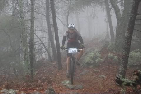 I would love to work up to something like that! I'm still fairly new to the sport, so I'm going to gradually expand my skills....if I get hurt riding my bike, I can't work, which means I can no longer afford to ride, so it's bad no matter how you look at it  That's why I would like a "skills park" to go play in, or at least more technical features on our trails..... |
|
|
|
Post by kconner on Dec 19, 2010 18:20:58 GMT -5
While I am fairly new to the sport and havn't tried anything I would consider "technical", I would like to see some trails with some technical areas so that I am able to progress in my skills. While I thoroughly enjoy every ride I take, no matter which trail I happen to be riding (it's just nice to get outside ) something "different" would be nice. It's a shame that some of the "technical" features of the FATS trails have been ridden around to the point that the technical line has "disappeared" (I know, it may not have disappeared, but I havn't been around long enough to know where a lot of them are). While I do enjoy a nice "cruise" through the woods, I would love to see more technical features to mix it up a bit, even if a second/alternate line has to be incorporated for those who don't want to try it. I would think it would be neat to have something like you see at some ski resorts (the "terrain parks") where you can have nothing but technical features to play on....something like the pump track but on a larger scale On a side note, I'm going to be in Cleveland, OH next week and will be checking out Ray's MTB with a buddy from the D.C. area, and was wondering if anybody local has been there....this will be my first time getting to really play with some technical stuff....VERY EXCITED!!! |
|
|
|
Post by kconner on Dec 15, 2010 16:49:24 GMT -5
As an FYI, since you obviously don't get it, most of us actually like the downed trees, they provide a challenge. If you don't like them, there are two great places you should ride where downed trees are always cut off. Here and here. There's always the tow path as well of course. +1....the towpath probably wouldn't work, it's got too many mud puddles ;D |
|
|
|
Post by kconner on Dec 11, 2010 0:08:54 GMT -5
Be careful out there, not all, but some of the homeless/transients in the area are mentally unstable and could pose a threat. I work part time with the ambulance service in Richmond County and deal with our homeless/transient population on a fairly regular basis, but there seemed to be something about this guy that worried me, even though I still can't put my finger on it. Considering that, and the fact that he was walking around with a machete, I mainly wanted to give everybody a heads up to be just a little more alert, especially if riding solo |
|
|
|
Post by kconner on Dec 10, 2010 16:56:26 GMT -5
Went out riding today and saw a guy dragging small logs around the trail in different places....later, I was taking a break at the fire pit, he walked past me and ignored my greeting. He then went and pulled a machete out of a nearby bush and told me he was building himself a cabin on the side of the river to replace one that had been in the same spot for 15 years. Needless to say, since I was by myself, I cut my ride short and headed back to the house.
Just wondering if anybody else has run into this person and knew what his story is?? I did see a platform of logs on the side of the river just off the Razor Edge the other day and assume this guy is the one building it, but have never seen a "cabin" or other shelter anywhere on or near the canal singletrack since I rode this trail for the first time about 8 years ago, so his story didn't exactly make sense me. Maybe I'm just being overly paranoid?
|
|
|
|
Post by kconner on Dec 8, 2010 17:54:42 GMT -5
That was pretty much the conclusion I came to after riding yesterday. I typically include the Razor's Edge (although I usually walk it most of the way since it's somewhat above my level, but it's got some good views of the river) but yesterday I decided to explore a bit out of curiosity. I just wanted to check and make sure I wasn't getting turned around Just out of curiosity, does anybody know anything about the history of the trail? Just wondering how long the trail has been there and what was there before the trail....I understand that some of the land on the other side of Rae's Creek was once part of a dump for the old City of Augusta and that squatters used to have houses throughout the area. It seems like I remember seeing old junk/trash throughout the trail when I first rode the trail in high school, glad that seems to have been cleaned up.... |
|
|
|
Post by kconner on Dec 8, 2010 15:34:06 GMT -5
Went for a short ride yesterday 12/7/10 and the trail was soft in just a couple spots (mainly in turns) but otherwise seemed to be in good shape. This was my first time riding in cold weather, it was interesting to see how different it looks after all the leaves fall. Anyways, after reading about the FATS reroutes, what exactly is the "correct" route on the Canal Singletrack? I saw several areas where the trail forks or shoots off, however, the only places I thought it was supposed to fork were for the technical section by the river (The Razor's Edge I believe) and for the Back or Southern Entrance. The newest fork that I havn't seen before is through the gulley/overflow by the back end of the borrow pits. I also took the right fork at the tree marked with a pink "X" going CW....I thought this was the less technical section by the river, but seemed to take me to a portion of the trail where I was travelling the wrong way....but I ended up continuing CW if that makes sense.
Anyways, just wondering what the "correct" route is, or if there are supposed to be options for a rider to take while riding.
|
|
|
|
Post by kconner on Dec 4, 2010 21:23:03 GMT -5
I've been to Sugar Mountain NC for the past two years and I'm getting ready to plan my third trip. It's about a 5 hour drive and seems to have the most to offer out of all the ski resorts within about a 6 hour drive from Augusta. Check out www.skisugar.com for all the info you need including current weather conditions, the forecast, and a webcam. Also check out the lodging/rental/lift ticket discount packages. |
|
|
|
KARMA
Dec 1, 2010 22:57:50 GMT -5
Post by kconner on Dec 1, 2010 22:57:50 GMT -5
+1
|
|
|
|
Post by kconner on Nov 24, 2010 16:38:02 GMT -5
Awesome!
|
|
|
|
Post by kconner on Nov 24, 2010 16:00:37 GMT -5
Thanks for the suggestions! Just out of curiosity, I see that you have to ride parts of one loop to get to another loop....how well are the individual loops marked, or are they marked at all?
|
|
|
|
Post by kconner on Nov 24, 2010 13:55:25 GMT -5
I'm getting back into the sport after a 3 month hiatus due to a broken foot, and am looking at riding FATS with a buddy of mine. However, neither of us have ridden FATS before. We're looking at starting out @ Skinny and possibly Brown Wave, but since neither of us have ridden out there, does anybody have any suggestions on which trails are best to start out on and what direction is best to ride each trail? Both of us are still fairly new to the sport with most of our time being spent on Old Bartram and the Canal singletrack. Thanks!
|
|
|
|
Post by kconner on Nov 10, 2010 13:40:30 GMT -5
Just to give you a heads up, Mistletoe, in my opinion is the hardest trail in the CSRA. Check out the creek crossings and other technical sections before riding them. The loops themselves are not well signed unlike FATS or Bartram so bring a map or better yet someone that has ridden the trail before. That being said it is a very fun trail. +1 I may be riding out there Sunday afternoon, I could show you around if you wanted. I'm actually recovering from a broken foot  and the doctor isn't letting me on a bike for another 3 weeks. That being said, I'm going to start back on Bartram and the Canal to get back into the swing of things.... |
|
|
|
Post by kconner on Nov 9, 2010 22:23:39 GMT -5
I'm fairly new to the sport....when looking for some new trails to ride, I searched Google Maps and found a map called "CSRA Mountain Bike Trails" that have all the local trails marked (including the back entrance to Mistletoe). I was able to download this and view it in Google Earth as well as on my Blackberry Hey, that's my map! That's the same map you get when you go to one of the Trails pages on our website and click the link to get directions. Here's another link to it.Go down Ridge Rd. It will turn to gravel. Keep an eye out for a white gate that will be on a fork to you left - park there. Ride your bike around that white gate and go down the woods road. Stay left at any fork you get to. Eventually there will be singletrack on your left, close to the bottom. It may be hard to spot with all the leaves down. If you reach the water, you missed it. Important thing to know - if you park at the back entrance to the park, be sure to wear your orange. You have to ride through some land that is hunted before getting to the state park property. Thanks for putting it together, it will be put to good use! As far as the back entrance is concerned, what is the parking situation? It appears on Google Earth that there is plenty of room to park without blocking access, and I'm assuming this is not on private property? |
|
|
|
Post by kconner on Nov 9, 2010 21:04:23 GMT -5
I'm fairly new to the sport....when looking for some new trails to ride, I searched Google Maps and found a map called "CSRA Mountain Bike Trails" that have all the local trails marked (including the back entrance to Mistletoe). I was able to download this and view it in Google Earth as well as on my Blackberry |
|


 That's why I would like a "skills park" to go play in, or at least more technical features on our trails.....
 and the doctor isn't letting me on a bike for another 3 weeks. That being said, I'm going to start back on Bartram and the Canal to get back into the swing of things....