|
|
Post by kconner on Jun 5, 2011 19:40:00 GMT -5
This is the tool I use: www.finishlineusa.com/products/chain-cleaner.htmworks great and is ~$25 at Academy Sports. Used the degreaser and lube that came with it until I ran out, then went to a local bike shop and bought what they recommended for lube/degreaser |
|
|
|
Post by kconner on Jun 2, 2011 11:47:31 GMT -5
Here's one that should get a response or two. EdgeE knows exactly where this spot is.  looks kinda like the rock garden at mistletoe, photographer looking clockwise, but the tread looks wider than I remember mistletoe being.... |
|
|
|
Post by kconner on Jun 2, 2011 11:41:15 GMT -5
just wanted to make sure the pumping station lot would be open, I couldn't remember what time the gate closed  |
|
|
|
Post by kconner on Jun 1, 2011 21:54:35 GMT -5
the log ride and bridge are both really cool, would LOVE to have something similar in the CSRA.....
|
|
|
|
Post by kconner on Jun 1, 2011 21:40:55 GMT -5
just in case i'll be able to make it, where is the best place to park?
|
|
|
|
Post by kconner on Jun 1, 2011 8:43:13 GMT -5
hopefully I'll be able to make it, but not for sure yet. Hopefully it'll get rained out so I can definitely make it at a later date |
|
|
|
Post by kconner on May 30, 2011 20:39:46 GMT -5
I ain't gonna lie dude: That's a smoking deal. That would make a great spare for a dust-gatherer for that "buddy that might show up". Additionally, I have several friends at work that always claim to want a "real mtb". They will get this link in their email box tomorrow. This blows away anything that Dick's or Academy Sports offers. MD +1 that's the bike that got me into mountain biking, and it's the bike (minus any upgrades) that I'm still riding Really great bike at a good deal, especially for a beginner. |
|
|
|
Post by kconner on May 26, 2011 8:26:00 GMT -5
check your messages.....
|
|
|
|
Post by kconner on May 26, 2011 8:21:51 GMT -5
havn't ridden Modoc yet, but this picture reminds me of Mistletoe, one of the stream crossings on the back half, maybe in the area of the rock dam....
|
|
|
|
Post by kconner on May 16, 2011 20:53:47 GMT -5
what color, and do you have any pictures?
|
|
|
|
Post by kconner on May 7, 2011 18:12:33 GMT -5
Thought that would be too easy New Bartram, at the water works road crossing. The road is an access road to the intake for the Clarks Hill Water Treatment Plant on Hwy. 221 |
|
|
|
Post by kconner on May 7, 2011 14:47:47 GMT -5
I have better ones on my computer at home, but we will give this one a shot: 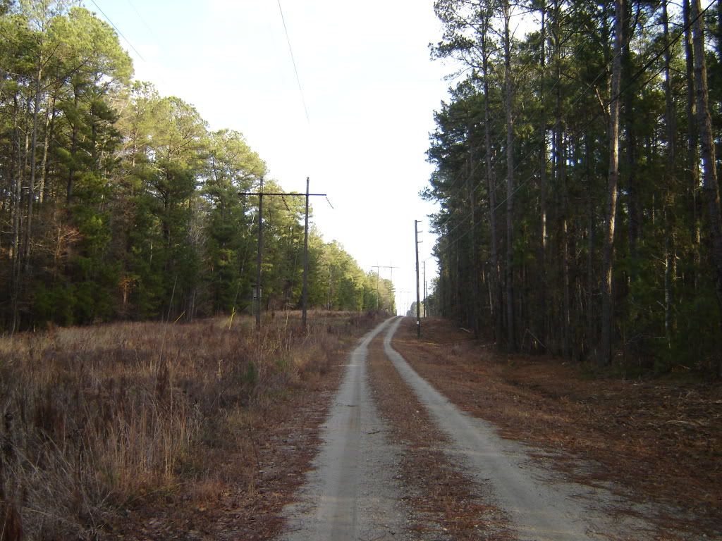 |
|
|
|
Post by kconner on May 7, 2011 8:56:59 GMT -5
I'll take a stab.....
The only place I've ridden that has anything armor that looks like this is Great Wall, about halfway through, but I thought the trees were bigger than in the above picture...
|
|
|
|
Post by kconner on May 4, 2011 18:10:51 GMT -5
Can the area's maps be combined so that one map it is able to be scrolled to see relative distance between different riding areas? That way someone unfamiliar with all the different areas could get a "big picture". These are .kml files, right? If so, open them in GoogleEarth (rather than Google Maps--look above the map) and they'll automatically import into your Temporary Places. Right click-->save as will put them into your My Places. Then you can view them all at the same time. Haven't tried this, but it should work. Or when you open to GoogleEarth you also have the save as option, which will let you save the .kml files directly to your drive. Then you can open into GoogleEarth from there. Yes, opening all wanted files in Google Earth would allow you to see all information at once (tracks and placemarks). Just download all files and zoom out. |
|
|
|
Post by kconner on Apr 30, 2011 21:34:18 GMT -5
I had a very good time even though I ran out of gas about 2/3 of the way through for some reason  Look forward to making the next one hopefully |
|
|
|
Post by kconner on Apr 29, 2011 9:08:04 GMT -5
I plan on showing up....what time does the ride start and where are we meeting?
|
|
|
|
Post by kconner on Apr 27, 2011 23:08:02 GMT -5
maybe add which days are CW/CCW for the Canal Singletrack?
|
|
|
|
Post by kconner on Apr 26, 2011 17:37:42 GMT -5
yes, I looked at labeling each road, (as well as parking areas, etc. for trails) but ran into the clutter problem myself. After fiddling with Google Earth for a few hours, I made no progress towards solving this problem and gave up. I definitely think some people may find a map of the FS roads useful, but what I currently have may need some polishing up to make it somewhat easier to use with labels and such. I'll send it as soon as I get a chance.
|
|
|
|
Post by kconner on Apr 26, 2011 10:15:48 GMT -5
I mapped out all the forest service roads in Google Earth (per the 2011 Motor Vehicle Use Map) if you would like to add it....let me know.
|
|
|
|
Post by kconner on Apr 24, 2011 21:28:41 GMT -5
thanks for the clarification dsquared. Havn't ridden Modoc yet, but I'm going to try to make it out that way in the next week or two.
|
|


 Look forward to making the next one hopefully