|
|
Post by kconner on Feb 21, 2018 21:10:43 GMT -5
Is Lower Skinny still closed? Rode Great Wall today and there was no tape at the Skinny/Great Wall intersection.....
|
|
|
|
Post by kconner on Jun 24, 2016 22:09:31 GMT -5
This has been a problem well before Strava.
|
|
|
|
Post by kconner on May 31, 2016 5:34:31 GMT -5
It is what it is. Yes, the people that want the line to stay need to ride it, but the people that want to ride around the rock need to stop throwing debris in the original line  ? |
|
|
|
Post by kconner on May 30, 2016 20:52:13 GMT -5
I agree with you Keith and I do think a solid alternative (as you said well built) line would be a good solution in this case. This feature ends up being part of the Skinny loop and I do believe continuing to try to force people to ride the root and rocks is simply an exercise in futility. I think people have made it clear they want to ride around the roots and rocks for whatever reason. Whatever ends up happening, it would be a shame to lose this line. I still don't get what clicks in people's heads that makes them say "this does not please me.....I'm just gonna do whatever I want with no regard to what time and effort others have put into this before I was here." |
|
|
|
Post by kconner on May 30, 2016 19:29:02 GMT -5
I can only speak for myself, but I've had to cut back on my riding time because of family and work commitments. However, when I was riding out there on a regular basis, I would block the bypasses. Later, sometimes in the same day/ride, I'd come through, and the materials used to block the bypasses would be thrown into the intended line. So as I see it, blocking the original/intended line is pretty intentional. I dunno why. I don't ride out there very much anymore, so I dunno what's going on out there now.
I'm in favor of alternate lines. Variety is the spice of life as they say....but if we are gonna have alternate lines, I personally think they should be sustainably designed, purpose built lines....not a new track two feet to the side of the original line. Just my two cents worth.
|
|
|
|
Post by kconner on May 29, 2016 18:14:28 GMT -5
When we (not they, "we" as in me and other locals) first built FATS, that was maybe the only technical feature out there. The "ride arounds" started immediately. Every time I would stop, and block those lines. And everytime the line would be back open the next time I came thru. I was always amazed about a few things: 1. That people were stopping and getting off their bikes and reopening these ride arounds. And the stuff I would put there would get further and further away. 2. They didn't stop when we actually put a sign there designating where the trail was built. 3. I would loudly and proudly say I was the one blocking the ride around lines. 4. The person(s) who were getting off their bikes and making the ride arounds have never spoken out as to why they are doing this, are proud of it and why they should do it. Never. 5. I will go back out there and make that ridearound path unridable. That line is going back over those rocks. 6. I promise. On a much larger scale, but same issue. rootsrated.com/stories/save-the-pinhoti-trail-from-unauthorized-modificationsI just don't get it. When I was new to mountain biking, the last thing on my mind was "let's see how I can change the trail to suit my purposes". In fact, I remember my first time out on Keg Creek.....I was in over my head, and hated the experience. So I waited, developed my skills, and now I enjoy Keg when I get the time to get out that way. The really funny thing is that the rock on Skinny is pretty easy, at least the way the majority of the people ride it. I used to return it to the original path, but I don't ride out there very much any more..... |
|
|
|
Post by kconner on May 2, 2016 21:10:11 GMT -5
Thunderstorms in the Martinez area right now, probably the same over there. I'd wait another full day at least before venturing out over there.
|
|
|
|
Post by kconner on Apr 26, 2016 12:03:02 GMT -5
 I know trails are going to evolve and such, but going around these rocks is blasphemy.... |
|
|
|
Post by kconner on Feb 10, 2016 11:39:29 GMT -5
You can't ride a 2x9 around here......(sarcasm)
Ride it and see if you like it. If not change it.....cassettes are cheap and easy to change.
|
|
|
|
Post by kconner on Dec 13, 2015 19:08:41 GMT -5
Just wanted to pop in and say that the erosion on this road really pushed the limits of the minivan that I took out there today to ride Big Rock and Tower. There are quite a few parts that are washed out and in bad shape, the van made it through them fine but I do not believe my car would make it (Hyundai Elantra) Try turning into 661 from the Woodlawn side (the north end of the gravel road), there's a small area you can pull off on the left hand side of the road. If I remember correctly, it's at the top of the hill, just down from the Big Rock trail crossing, and is before any serious erosion starts. |
|
|
|
Post by kconner on Aug 28, 2015 21:00:22 GMT -5
None of the local shops really sell used bikes unless they happen to have something sitting around that may have been traded in. Craigslist is typically not worth your time if you're looking for a break in price.
If you're interested in staying on FATS for now, there's probably nothing wrong with your current set up. FATS is typically considered to be fairly tame as far as singletrack goes, and it's common to see fully rigid and/or single speed bikes out there. That being said, if you really want a suspension fork, you may have some luck buying a used fork by itself.
Good luck!
|
|
|
|
Post by kconner on Mar 31, 2015 21:05:49 GMT -5
The SORBAcsra NMBP has been asked to help with with both the Best Dam Ride and the Lock to Lock ride again this year! If you're available and would like to help out with either of these fun events, let me know and I'll get you added to the list for future updates!
|
|
|
|
Post by kconner on Mar 8, 2015 18:30:34 GMT -5
I haven't been out there in a while, but when my back yard holds water, so does FATS. And my back yard is still holding water.
Tons of options out there for gravel road rides, and they can be as much fun as singletrack.
|
|
|
|
Post by kconner on Feb 12, 2015 7:24:13 GMT -5
My understanding is that it's still pretty sloppy. I'd ride gravel roads or outlying trails.
|
|
|
|
Post by kconner on Jan 27, 2015 18:08:58 GMT -5
Well, I've been across that bridge then, I just don't remember it.
If the trees you're talking about are the ones I'm thinking about, then yeah, that's super sketchy....I wouldn't wanna cross those either!
|
|
|
|
Post by kconner on Jan 26, 2015 21:12:35 GMT -5
Looks like a nice route! That's a fun creek crossing when it's warm and/or when the water is down....was the water up and over the rocks a few yards downstream from where the two roads would connect if they didn't dead end?
The road by the field is one of my favorites that I've come across....
Where's the smiley face bridge?
|
|
|
|
Post by kconner on Nov 21, 2014 21:10:23 GMT -5
Rode this route today: 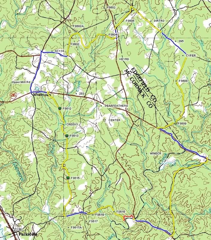 Good loop of mostly gravel around the Turkey Creek / Wine Creek area. Perhaps a few hundred yards of trespassing in the FS 618 area. If you ride this loop and start at Key Bridge, I'd ride it CCW. There is a creek crossing at the end of FS 619 in which you will get your feet wet. If you go CCW, you will do this with 2 miles to go. If you go CW, you will do this with 30 miles to go. The creek crossing on FS 612, 613 is a hike a bike. You should stay dry there. Red is singletrack, yellow is gravel and blue is pavement. Great route if you're looking to get some miles in with a couple of decent climbs. About 99% of the route is well marked and ridable right now, with only a couple of missing road signs. There has also been some logging activity along FS 612 and the path leading to the creek crossing is hard to see if you don't know where it is. Other than that, this route perfect! |
|
|
|
Post by kconner on Oct 18, 2014 8:45:05 GMT -5
Keg CW to Mistletoe. Mistletoe CCW and back to finish Keg.
|
|
|
|
Post by kconner on Oct 17, 2014 9:00:21 GMT -5
So far, looks like 6 people will be ridining....anybody else is welcome to join! We will be meeting at the main parking lot for Keg....take Washington Road towards the lake. Go straight through Pollards Corner. Once you pass over the Keg Creek bridge, the parking lot is immediately on the left. Wheels roll at 9:00 am, no later than 9:05  |
|
|
|
Post by kconner on Oct 12, 2014 14:43:07 GMT -5
Looking to get a group together and enjoy a nice, easy ride on the Christmas Party Ride route on Sunday October 19. This will be an intermediate paced ride....if you want to go ahead of the stragglers, that's fine, but the slower riders will not be dropped. I should be flexible on time, but I would prefer to ride in the morning, maybe around 9-9:30. If you're interested, reply to this thread. An exact time will be settled on closer to the date of the ride and will be listed on this thread. The Christmas Party Ride is a combination of the Keg Creek and Mistletoe State Park trails, linked together by a short section of road for a total of around 25 miles of riding. Lots of technical riding, including logs, creek crossings, roots, and even some gullies and rock gardens. If you're not comfortable riding some of the technical stuff but want some decent mileage, it's all easy enough to walk. Stragglers will not be dropped! Let me know if you're interested by posting here. A concrete time will be decided on before October 19 and will be based on the schedule of those interested in riding. This is not an official SORBAcsra sponsored ride, so riders will be on their own for hydration and nutrition. Happy Trails!! |
|


 ?
?
