|
|
Post by Angela on May 6, 2016 14:22:13 GMT -5
We still need 2 or 3 volunteers to step up and help carry materials in and assist in rebuilding a bridge that is out on Keg Creek. This work party is for tomorrow morning so if you can assist please send an email to SORBAcsraThank you! |
|
|
|
Post by Angela on May 5, 2016 20:36:23 GMT -5
FATS is officially open!
|
|
|
|
Post by Angela on May 4, 2016 20:32:22 GMT -5
Watching the various lines of heavy rain move through our area on Monday, I did note that the Bartram Trail did not appear to get the heavy rain that rolled through south of the lake. A check of the rain gauge at Thurmond yesterday revealed that it had picked up about half an inch. Rode Bartram east tonight and it was dry.
|
|
|
|
Post by Angela on May 3, 2016 17:52:04 GMT -5
June Explore The Trail Ride and Cookout What: Ride and cookout celebrating National Trails Day Where: Long Cane Horse Trail When: Saturday, June 4th meet at 9:30 the ride starts at 10:00 - cookout follows This ride/picnic can be cancelled due to weather or trail conditions so please check this forum prior to leaving for the event! We need a count of people interested in joining us for this ride/picnic so we can plan for food so we will be posting a Survey Monkey poll shortly to make it easy to sign up for this event! The Long Cane Horse Trail is near Greenwood , SC allow about an hour and 30 minutes from Augusta . Meet at 10:00am at the Fell Horse Camp (directions to follow). We will be serving lunch (hamburgers, hotdogs and sides) at shortly after noon at the pavilion at the Fell Horse Camp. Members and non-members are welcome! This trail system is a great flowing trail cut through varying terrain - tremendously fun and well worth the drive! You can easily put in 14 miles but many do over 25! There will also be a 25 mile gravel grinder. If you haven't ridden this trail system before put this event on your calendar! Please come join us, the Greenwood SORBA-CSRA members are always fantastic hosts and they do an excellent job of maintaining and improving this trail. We will have some ride leaders and people sweeping and with the various ride options available (short and long), everyone should have a great time. Ashby Stokes will be back to provide some first class entertainment during the cookout. The last couple of years we have had the pleasure of hosting 60 to 70 mountain bikers at this event.  Always good food and great times after the ride. 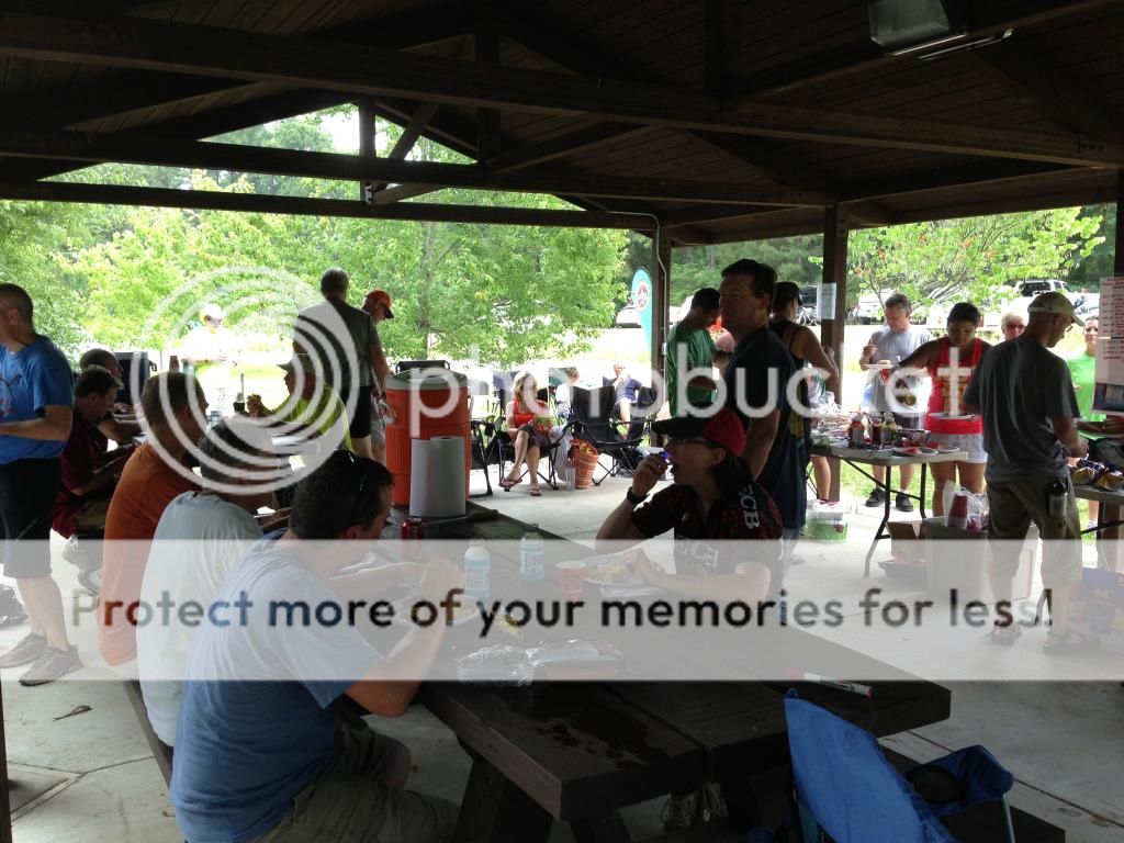 Ashby Stokes is a great entertainer (and a really good mountain biker too) so happy to have him back again this year!  |
|
|
|
Post by Angela on May 3, 2016 12:16:23 GMT -5
FATS is officially CLOSED. The US Forest Service has enacted an official closure of FATS due to wet trail conditions. You can check our homepage, the USFS Call Before You Haul Hotline (803-561-4025), our Twitter Feed @fatsupdate, or our Facebook page for updates. Please respect the official closure and thank you for your support. Stay tuned for updates! 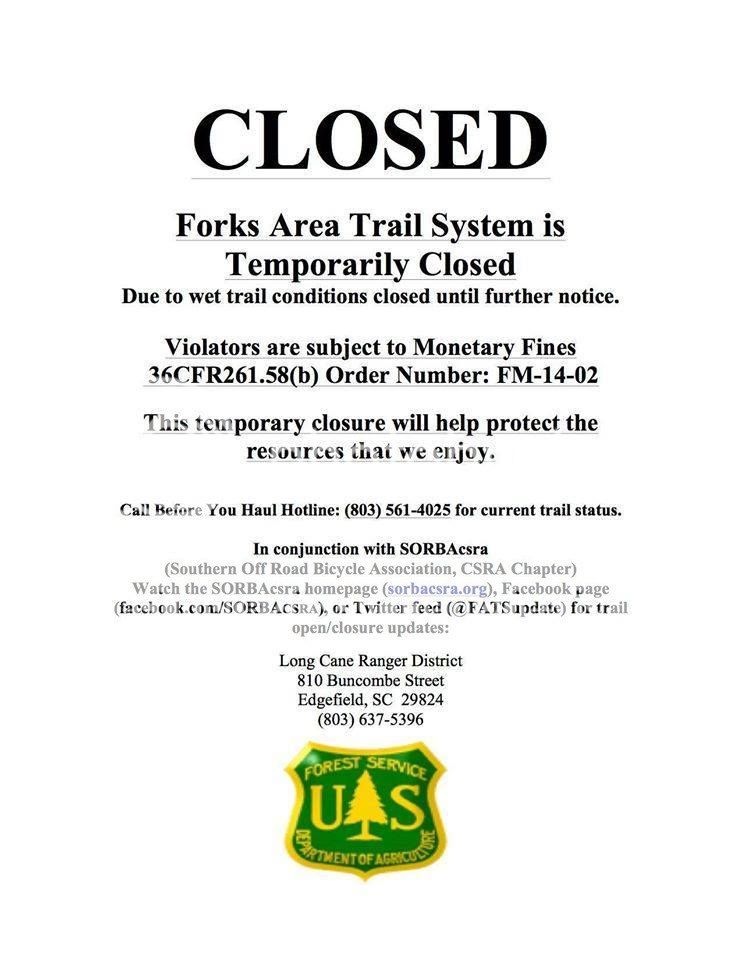 |
|
|
|
Post by Angela on Apr 22, 2016 12:30:07 GMT -5
FATS is open (and has been since the 10th of April)!
We do have rain heading our way but since we have not had any significant rain since April 1st the trails are pretty dry. Unless we end up with a serious deluge of several inches I expect the trails will be good to go this weekend. Keep an eye out here, our homepage, Facebook or Twitter for up-to-date information.
Thank you!
|
|
|
|
Post by Angela on Apr 18, 2016 21:49:44 GMT -5
Thanks for the update Deano. We have trees on several trails down right now and in the meantime all the moisture in the soil has really spurred the growth of the foliage. Looks like we will have our hands busy this spring. I'll pass the word along to a couple of our chainsawyers who try to keep Modoc clear. They usually end up with an unexpected clear spot in their schedule and then head to do the sawing but I will let them know you might can help!
|
|
|
|
Post by Angela on Apr 17, 2016 20:47:47 GMT -5
Explore The Trails RideWhen: Sunday May 8th, 2015 at 1:30pm Where: Mistletoe State Park - meet in main parking lot (in front of the ranger's station) What: Mistletoe has multiple loops for a total of about 13 miles There is a $3 parking fee in Mistletoe. Mistletoe State Park websiteThis trail is an intermediate/advanced trail (based on area trails) but there will be a ride leader and all features (Rock Dam, etc have alternate lines or can be walked)! For more information!How to get there> Mistletoe State ParkAre you always riding at FATS?  ........ Here is a chance to get out and explore one of the other trails in the area. This ride is for SORBA & Non-SORBA members. There will be ride leaders. So come on out and join the fun! In the event the weather or trail conditions are not acceptable the ride will be cancelled so watch postings here! Questions?? Email SORBAcsra
|
|
|
|
Post by Angela on Apr 17, 2016 20:30:57 GMT -5
Trails are in good condition right now with just a handful of wet/mucky areas. Several areas are slated for repairs in the coming months. There are a handful of sandy areas developing which might be the result of erosion/washing during some of the heavier rain over the past few weeks.
|
|
|
|
Post by Angela on Apr 12, 2016 6:27:20 GMT -5
A cold front headed our way yesterday and it looked like we were going to get hammered with rain, in fact it settled down before arriving so we ended up with several hours of rain beginning just after midnight but much less than expected. More scattered rain expected today and then the trails will need at least a day to dry out. Please give the trails at FATS a chance to dry out - will be okay to ride outlying trails! Thank you. Attachments:Weather 04-12-16.jfif (82.01 KB)
|
|
|
|
Post by Angela on Apr 12, 2016 6:19:02 GMT -5
This trail has certainly had its share of trees down this year, thanks for the update, we will add these to the list.
|
|
|
|
Post by Angela on Apr 12, 2016 6:18:07 GMT -5
Thanks for the feedback, we'll add these to the list!
|
|
|
|
Post by Angela on Apr 12, 2016 6:17:14 GMT -5
Thanks so much for the feedback, we will get those trees added to the chainsaw list!
|
|
|
|
Post by Angela on Apr 10, 2016 12:10:06 GMT -5
FATS is officially open!
There are still wet areas, please ride in the middle of the trail.
|
|
|
|
Post by Angela on Apr 7, 2016 11:11:57 GMT -5
FATS is still under official USFS closure.
A trail check earlier in the week revealed water still running down and across the trail in many spots. Last night a relatively fast-moving system moved through the area dumping rain in a torrential downpour. Stay tuned for updates!

|
|
|
|
Post by Angela on Apr 1, 2016 21:26:22 GMT -5
This ride (the Explore the Trail Ride at Modoc on Sunday, April3rd) is cancelled due to wet trail conditions.
|
|
|
|
Post by Angela on Apr 1, 2016 12:59:23 GMT -5
FATS is officially CLOSED.
The US Forest Service has enacted an official closure of FATS due to wet trail conditions.
You can check our homepage, the USFS Call Before You Haul Hotline (803-561-4025), our Twitter Feed @fatsupdate, or our Facebook page for updates.
Please respect the official closure and thank you for your support.
|
|
|
|
Post by Angela on Mar 28, 2016 22:13:43 GMT -5
When: Sunday April 3rd at 1:30pm Where: Modoc Trailhead on hiway 23 in SC near Modoc, SC What: Modoc (Stevens Creek) Trail - In/out trail total mileage approximately 11 miles This trail is an intermediate trail but suitable for fit novice riders as well. There are 3 creek crossings as well as some cool terrain changes along this trail. The ride is for SORBA and non-SORBA mountain bikers so bring your friends. In the event the weather or trail conditions are not acceptable, the ride will be cancelled so watch for postings here! Any questions email us at sorba.csra@gmail.comMore information on Modoc Trail!
|
|
|
|
Post by Angela on Mar 28, 2016 6:24:51 GMT -5
Large rain system rolled through the area over the weekend it will take AT LEAST 48 hours for the trails to dry out. Please let the trails dry out before you ride. Stay tuned for updates.
Thank you!
|
|
|
|
Post by Angela on Mar 11, 2016 11:22:27 GMT -5
FATS is officially open! Please use caution particularly when riding in areas that were burned.
|
|


 ........ Here is a chance to get out and explore one of the other trails in the area.