|
|
Post by beckyl on Feb 17, 2014 8:29:38 GMT -5
A small crew (Becky & Nevin Lambert and Ted Stoddard) out on both Turkey Creek and Wine Creek were able to do debris and tree cleanup with a handsaw (no chainsaw work required)and reported that trail did not sustain extensive damage. The trail is still extremely wet though. Just to clarify, we did take out about 20 trees with a chainsaw on Wine and Turkey but most of them were skinny pines that were off the ground enough to make you dismount. I didn't think to get pics of everything because we wanted to cover as much ground as possible. Despite this, we were very surprised it wasn't worse. We ended up spending most of our time on Wine tunneling through the dense sections. Thanks for the pics of FATS. We intend to do a lot more sawing over the next few weeks. |
|
|
|
Post by jpick915 on Feb 17, 2014 10:31:13 GMT -5
A buddy and I are planning on driving down from the Cincinnati area next Monday (2/24) to ride Tues, Wed, and Thursday. So far the weather looks good (Weather.com forecast), but want to make sure that we will not be wasting our time if the trails will be unridable. I have never been to the area, so your input would be helpful.
Also, anyone care to recommend a campground in the area?
|
|
|
|
Post by Angela on Feb 17, 2014 12:21:54 GMT -5
A small crew (Becky & Nevin Lambert and Ted Stoddard) out on both Turkey Creek and Wine Creek were able to do debris and tree cleanup with a handsaw (no chainsaw work required)and reported that trail did not sustain extensive damage. The trail is still extremely wet though. Just to clarify, we did take out about 20 trees with a chainsaw on Wine and Turkey but most of them were skinny pines that were off the ground enough to make you dismount. I didn't think to get pics of everything because we wanted to cover as much ground as possible. Despite this, we were very surprised it wasn't worse. We ended up spending most of our time on Wine tunneling through the dense sections. Thanks for the pics of FATS. We intend to do a lot more sawing over the next few weeks. Many apologies Becky - saw Nevin's report that nothing big came down on either trail, although there were lots of small trees and in my haste this morning trying to get the information on FATS posted before I left for work I assumed (and we all know what that gets you ; ) handsaw! Thanks for correction! |
|
|
|
Post by Angela on Feb 17, 2014 12:35:28 GMT -5
A buddy and I are planning on driving down from the Cincinnati area next Monday (2/24) to ride Tues, Wed, and Thursday. So far the weather looks good (Weather.com forecast), but want to make sure that we will not be wasting our time if the trails will be unridable. I have never been to the area, so your input would be helpful. Also, anyone care to recommend a campground in the area? I highly recommend that if the purpose of your trip is to ride our local trails that you reschedule your trip. We had a huge amount of damage in the CSRA (Central Savannah River Area)due to an ice storm last week and as of this morning there are still 7,500 customers in Aiken County without power. We have 150 miles of singletrack we maintain and are just beginning to assess how widespread the damage is across the trails. Many of our regular volunteers are still tied up trying to clean up the mess on their own property this week. FATS appears to be hit the worse and many of the USFS roads that FATS crosses are currently impassable. The USFS will have to get those roads opened back up before we can get work crews in to start cleaning up the trails. From my personal observation (and I did not walk all 36 miles)at every point I checked - the trails are currently unrideable. We also have rain in the forecast this week that will further slow up the recovery. We do have great trails in the area but highly suggest that you plan your trip for after the cleanup. Check back on our forum or like us on Facebook SORBA CSRA or Twitter FATSUpdate! For when you do make it down, here is some camping information: Petersburg Campground www.reserveamerica.com/camping/Petersburg_Ga/r/campgroundDetails.do?contractCode=NRSO&parkId=71348&topTabIndex=CampingSpotThe Petersburg Campground is located next to the Bartram Trail - this trail system is not technically difficult and there is very little elevation change but you can ride for miles! sorbacsra.org/Trails/Bartram.htm Read more: sorbacsra.proboards.com/thread/2778/2012-camping-information#ixzz2tbMmUr4W |
|
|
|
Post by mhanna on Feb 17, 2014 14:10:13 GMT -5
If you can't change your trip dates I'd suggest maybe heading to Pisgah Forest or DuPont State Forest in Brevard North Carolina. They got snow and not ice so the trails there should be fine. Excellent riding for all ability levels.
DuPont is fantastic and beautiful with many waterfalls and intermediate level trails. Pisgah is a step up in difficulty but has some of the finest backcountry riding in the Southeastern US.
You can check out their website at PISGAH SORBA or call the Hub Bike shop in Brevard for more info.
You can camp there in the middle of all the fun at Davidson River Campground.
FATS is not going to be any condition to ride for some time unless we get an extended dry spell. Even without the ice damage is was a mushy wet mess. No fun to ride and no good on the equipment.
|
|
|
|
Post by pat656 on Feb 17, 2014 14:34:13 GMT -5
Pisgah and DuPont are currently under snow, could be clear by the weekend but are going to be really wet and muddy.
|
|
|
|
Post by Ross D on Feb 17, 2014 15:11:52 GMT -5
Rode/crawled/walked the gravel roads at FATS today.. Unbelievable.. I can't even imagine what the trails are like.. Duck Pond Rd, I think the furthest I rode at a time was 100 yards.. It's all going to need an amazing amount of work.. Once Southern Cross is over with, I'll be able to help out..
|
|
|
|
Post by dsquaredmsquared on Feb 22, 2014 16:16:34 GMT -5
Wow!!! What a work day at FATS!!! We had 13 volunteers show up to the work party this morning, including two USFS certified sawyers, and after 6 hours of trail work, only made a dent in clearing the ice storm damage. • The east side of Big Rock is completely clear. • Tower and the west side of Big Rock were cleared by handsaw, but there are larger trees still down. • A 2 mile section of lower Skinny is completely clear. • Tower was surprisingly dry, Big Rock not bad, Skinny is too wet. • FS661, from Deep Step Road to north trailhead, is clear, with only two trees to negotiate. From Woodlawn Road, lots of trees on 661 to negotiate and ride over; not suggested for low riders. A big thank you to Paul F., Steve S., Rich W., David S., Bill S., Don A., Lowell D., Fred G., Katherine B., Seth Y., Heather R., and Scott D. for spending most of their Saturday giving back to our trails. It will take many weekends of work to get FATS back to a new normal. Stay tuned for information about our next work party. Pics from FATS work party 02.22.14 is on FB page at goo.gl/i7NHhd (no login required). |
|
|
|
Post by dsquaredmsquared on Feb 23, 2014 18:59:52 GMT -5
Recent progress and pics of what used to be the Skinny loop are posted on the SORBAcsra Facebook page (no login required) or check out the FB feed on the SORBAcsra home page. Hard to imagine how long it will take to get FATS back to normal if Brown Wave, Great Wall, and Deep Step look like this too. |
|
|
|
Post by Angela on Feb 25, 2014 7:17:50 GMT -5
Just to make sure everyone caught this (and unfortunately the 3 large logs at the entrance to FATS were removed by the contractor who is responsible for the upcoming burn out at FATS so might make people, who are not checking trail conditions via our homepage, Twitter, Facebook or forum, assume the trail is open)> Please do not ride/run FATS unless you are volunteering with trail cleanup and are very familiar with the trails. Only a few miles of trail are clear and the large amount of ice storm debris has made most sections of trail impassable and largely unrecognizable. There was a S&R incident last night at FATS, after someone not familiar with the trails encountered a section of trail blocked by storm debris and got lost. If the USFS decides to close the trail because of safety issues related to the ice storm damage, it will become even more difficult, and take much longer, for us to clear the ice storm debris and get the trail back to normal. Please tell your friends not to walk/hike/run/ride FATS until all the ice storm damage is repaired. Thank you for your support. edgefielddaily.com/merriwether022414.html |
|
|
|
Post by Angela on Feb 27, 2014 7:08:33 GMT -5
There will be a work party at FATS this Saturday (March 1)at 9AM - watch for more details!
|
|
|
|
Post by dsquaredmsquared on Feb 27, 2014 10:40:11 GMT -5
FATS work party
Saturday, March 1st at 9:00AM. South parking lot.Please RSVP to dave.sorbacsra@gmail.com, so we can have a head count and plan work groups. We’ve found that some loops at FATS are so damaged that it is best to have volunteers walk/hike the whole loop, whereas damage on other loops is spaced out and riding/running is a more efficient approach to clearing debris. Therefore, be prepared to either HIKE a loop and/or BIKE/RUN a loop, depending upon your trail assignment. Since many of the access roads are still blocked, it will take longer, and more effort, to get on/off your assigned trail. Expect to be on the trail for 4-6 hours. To help us form work groups, please be prepared to: • depending upon assignment, walk/hike while clearing several miles of trail • depending upon assignment, bike or run while clearing several miles of trail • bring a folding handsaw or loppers – we have extra loppers to loan out • safely and securely carry tools in a CamelBak or hydration pack while hiking, riding, or running and clearing trail • dress appropriately for weather conditions and physical activity on the trail • bring/wear work gloves • bring water, food, snacks in hydration pack - you will be on the trail and your car will likely be miles away. Thank you for your support and we’ll see you Saturday morning.
|
|
|
|
Post by Angela on Feb 28, 2014 7:36:58 GMT -5
Looks like we will have 6 of our certified sawyers at the FATS work party on Saturday morning. If we have enough volunteers signed up to help with the hand cutting and debris removal, we can really make a dent and get this trail system back ready to ride. Remember Daylight Savings Time starts March 9th so the sooner we get these trails cleared the sooner we can be hitting those trails after work!
|
|
|
|
Post by tm2014 on Mar 2, 2014 6:44:03 GMT -5
Have been planning a trip up to FATS from central Florida for weeks now. Was going to cancel until I saw the amazing amount of work you all did on Saturday. Congrats and thanks from all of us. My only question now is, will the trails be dry enough to ride by next Saturday, 3/8? We really want to come up and ride (the last trip was ruined by the government shutdown), but we don't want to do damage to the trials either. Looks like you may have one day of rain this week, but otherwise dry. I would appreciate any thoughts. Thanks.
|
|
|
|
Post by Angela on Mar 2, 2014 9:13:47 GMT -5
I am getting ready to post the status of the trails from our SORBAcsra FB page but to answer your question.... the trails are in pretty good shape right now treadwise (except Great Wall and work has not finished on that trail and it is still too wet). We have been getting about a third of an inch of rain in the area over the last couple of weeks the main moisture came from that big ice storm. So the wet on the trails is not from recent rain it is because the water levels in the ground are so high it is feeding those seeps.
Right now on the radar I see 60% chance of rain on Monday and then 70% chance of rain on Thursday. It would really depend on how much rain and where, but if you aren't able to make the call at the last minute you probably need to wait to make the trip. A lot of foliage has begun to come to life here as we are moving into Spring. Once the foliage starts utilizing all that extra rain and underground water the trails will hopefully stay drier (2013 was an unusually wet year).
Feel free to contact us via sorba.csra@gmail.com, watch our SORBA CSRA Facebook page, follow us at FATSUpdate on Twitter or even continuing to check here on the forum!
Thank you!
|
|
|
|
Post by Angela on Mar 2, 2014 9:15:24 GMT -5
From our SORBA CSRA Facebook timeline> but I will add that Great Wall is also still reportedly too wet to ride> Information and conservative estimates of ice storm cleanup, as of 03.01.14... • more than 50 volunteers (that we know of; some prefer anonymity) • ~350 hours volunteered • more than 1,200 trees cut by chainsaw or handsaw • ~90% of 35 trail miles at FATS are clear of ice storm debris • Deep Step is clear • Deep Step connector to BR/T is clear • Big Rock is clear • Tower is clear • Skinny is clear • Brown Wave is nearly clear. Traveling ccw... - between mile marker 5.0 (FS662) and power line still needs handsaw and chainsaw work (<0.75 miles). • Great Wall is nearly clear. Traveling ccw... - between mile markers 0 - 2.5 there are 5-7 trees that need chainsaw work. - between mile markers 2.0 - 2.5 there may be chainsaw or handsaw work. - between mile marker 6.5 and Skinny intersection (<1.0 miles) several trees need chainsaw work. We will put these remaining sections of trail on our todo list and knock them out over the next few weekends. Please remember that only USFS Certified Sawyers are permitted to use chainsaws on USFS land, including FATS. There are too many volunteers to list and thank individually, but I don't think anyone would argue that Steve S. and his crew (David C., Bryan L., Jerry M., Steve P., Robert S., and Rich W.) deserve special recognition for their herculean efforts to clear Skinny, which was the hardest hit of all the loops at FATS. It took them at least 4 or 5 long days of chainsaw work to clear piles, upon piles, of fallen trees, and its only a 6.5 mile loop. Thank you Steve and your cutting crew for giving back to FATS. And, thank you to every single person who volunteered at FATS over the last couple weeks. p.s. If you have pictures from the work party, please send them to us and we will post on our FB page. p.s.s. Now, we need to have a conversation with the USFS. FATS was hardest hit in the Long Cane Ranger District and should have been a cleanup priority for the land manager, yet communication and support for the cleanup was underwhelming. If volunteers did not step up so quickly and commit to restoring the trail, the cleanup of FATS would currently be the few trees cut at the trailhead, which is not acceptable. Stay tuned. Pictures are post on the SORBAcsra FB page. No login required. |
|
|
|
Post by Ross D on Mar 2, 2014 22:45:58 GMT -5
Thanks Angela for the update..
|
|
|
|
Post by Angela on Mar 6, 2014 12:57:56 GMT -5
We had light rain in the CSRA earlier in the week and now this system moved in before noon and it looks like it will be raining for hours. Although the weekend looks clear with warm temperatures, FATS will be too wet to ride. Please do not ride wet trails. Thanks! 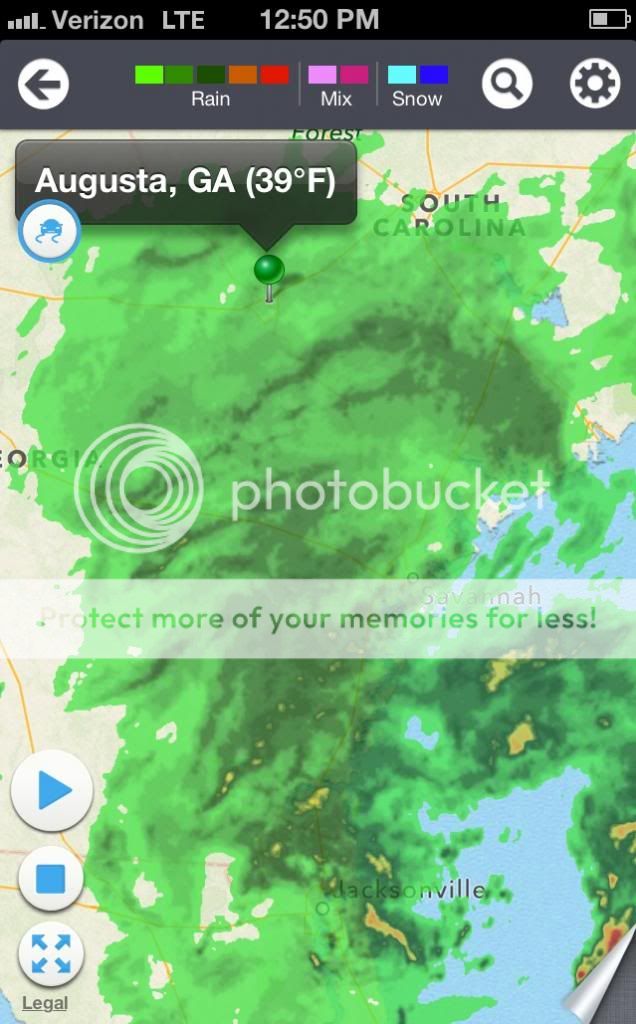 |
|
|
|
Post by Angela on Mar 7, 2014 6:50:23 GMT -5
Unfortunately we had about 16 hours of rain before the system slid off to the east. It is going to be days before these trails will be dry enough to ride again. Stay tuned via Facebook, Twitter or here for updates.
|
|
|
|
Post by crockpot2001 on Mar 11, 2014 14:42:01 GMT -5
Rode BR and Tower last night about 5PM. Pretty wet for the first 1.5 miles of BR going clockwise. All on the entire network opened at least 30 drains. It looks like it got lots of wheels this last weekend when it was really wet. Wednesday's rain won't help.
|
|