|
|
Post by jtaylor on Apr 27, 2011 10:54:44 GMT -5
If YC is right then I'm lost; I thought this picture was older than new Bartram; bottom of a hill, half way around a loop.
|
|
|
|
Post by dparrott on Apr 27, 2011 20:57:49 GMT -5
Brian - You were NOT there when this was taken. YC: not even close.
This is a bit of a trick picture!!
|
|
|
|
Post by brianW on Apr 28, 2011 10:12:36 GMT -5
ok, I was thinking it was the bridge just before Pollard property.
|
|
|
|
Post by Catalyst on Apr 28, 2011 10:37:31 GMT -5
Was thinking this when I first saw it, but knew it looked too new. Now that dparrot mentions it's trick picture...how about this for a guess: the bridge 3/4 of the way to the end of Modoc, but taken several years ago.
|
|
|
|
Post by dparrott on Apr 28, 2011 20:14:36 GMT -5
Catalyst: on the right track but wrong trail!
|
|
|
|
Post by dgaddis1 on Apr 29, 2011 6:46:26 GMT -5
Catalyst: on the right track but wrong trail! I'm going to say it's on Keg Creek. Couldn't tell you where though. |
|
|
|
Post by jtaylor on Apr 29, 2011 11:12:56 GMT -5
OK, I will put you guys out of your misery- Great Wall, only bridge on GW, at the half-way point, bottom of the hill. Picture taken when it was brand new.
|
|
|
|
Post by seenvic on Apr 29, 2011 11:34:32 GMT -5
OK, I will put you guys out of your misery- Great Wall, only bridge on GW, at the half-way point, bottom of the hill. Picture taken when it was brand new. I thought it may be that, but the drainage on the left kept me from saying that. I couldn't place that drainage anywhere. |
|
|
|
Post by dparrott on Apr 29, 2011 20:02:56 GMT -5
Correcto-mundo, JT.
The bridge on Great Wall - right after it was constructed by SORBA on Grand Opening Day of FATS - 3/25/2006. The time shift tends to throw your perspective.
|
|
|
|
Post by jtaylor on May 1, 2011 15:32:19 GMT -5
OK; try this:  |
|
|
|
Post by tzeaser on May 1, 2011 15:47:32 GMT -5
End of Modoc looking at the trail from FS 632A
|
|
|
|
Post by jtaylor on May 2, 2011 7:05:32 GMT -5
ding ding ding
your turn
|
|
|
|
Post by tzeaser on May 2, 2011 7:55:07 GMT -5
I was afraid of that - I don't have many trail pics. I'll see what I can find...
|
|
|
|
Post by tzeaser on May 2, 2011 8:28:10 GMT -5
I had to go way back to find this: 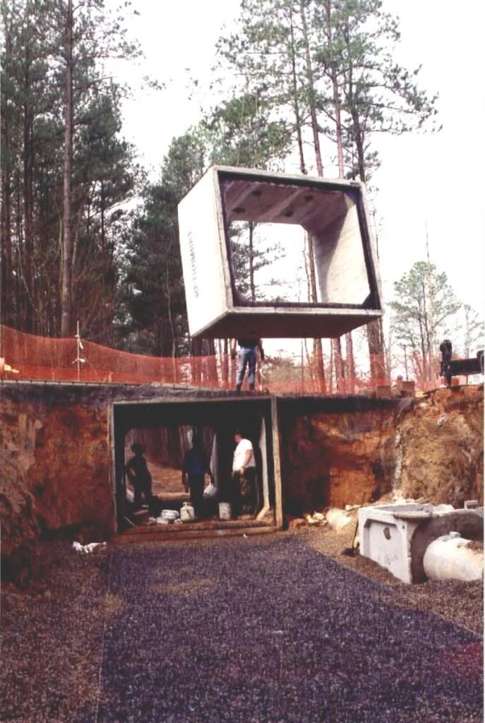 |
|
|
|
Post by azdrawdy on May 2, 2011 10:03:08 GMT -5
Greeneway?
|
|
|
|
Post by tzeaser on May 2, 2011 10:15:24 GMT -5
Of course. It is the tunnel under Riverbluff Drive in The Rapids, constructed in the first phase of the Greeneway in 1996. What is significant is that it was installed by city crews. It's nothing fancy, but still a good feat for a public works department.
|
|
|
|
Post by azdrawdy on May 2, 2011 20:46:28 GMT -5
|
|
|
|
Post by seenvic on May 2, 2011 21:26:50 GMT -5
Brown Wave....when it was being built. I think that is on "shuttle run". The DH going CW b/n the gravel roads.
|
|
|
|
Post by dparrott on May 2, 2011 21:27:33 GMT -5
By the width of the machine made tread, I'd guess FATS but not a clue where.
|
|
|
|
Post by azdrawdy on May 3, 2011 8:16:11 GMT -5
Definitely FATS. 1st hint: Not BW.
Think sand.
|
|