|
|
Post by seenvic on Aug 17, 2011 9:59:36 GMT -5
A new SMC course has been on my mind lately.
Been working on routes that use only Modoc, Turkey, Wine trails. We'd lose Horn Creek as part of the route. The Modoc to Horn Creek section has 12-14ish miles of pavement and is the biggest source of complaints concerning so much pavement. I am thinking of a figure 8 loop or lollipop loop where you ride singletrack, then get off it, and then come back to the trails going the opposite direction.
Timing and distance are key here. Have to have a route that is just about perfect in terms of the fastest riders not getting so far out in front that they are coming back on the singletrack BEFORE the slowest riders get off the singletrack for the first time.
Could be that we use this as a cut off, or as a route shortener for the folks at the back. Perhaps have a point on the course when the leader gets too, all traffic still going "out" on the single is routed off the trail and back onto the course with a shortcut.
I keep thinking I'd like to get the racers onto Modoc, then over to Turkey. Turn off Turkey onto gravel and ride pavel all the way to top of Wine Creek at 283. Then have it go back Wine, Turkey and Modoc to the finish.
HBSP was a good staging spot, but it adds almost 5 miles of pavement. Modoc Speedway doesn't have the shade HBSP has. The perfect location may be Price Mill....but that is private property and I don't know what they'd think if we pitched that to them. Perhaps the town of Parksville would work. Prolly be the biggest crowd in Parksville this century!
Thoughts?
|
|
|
|
Post by dgaddis1 on Aug 17, 2011 10:27:41 GMT -5
I like the idea of leaving out Horn, it's just too far away from the other trails, most folks don't seem to think it's worth the 30 miles of connectors to get to and from it. Sticking to the Modoc/Turkey/Wine corridor also gives us options for shorter routes, broadening the race's appeal to a lot more people.
I don't think a cut-off time/location is a good idea, where we route people off the main course. Those folks wouldn't get the ride the whole course they paid to ride.
We could try and limit any head on traffic to a pavel connector.
|
|
|
|
Post by seenvic on Aug 17, 2011 10:49:46 GMT -5
I like the idea of leaving out Horn, it's just too far away from the other trails, most folks don't seem to think it's worth the 30 miles of connectors to get to and from it. Sticking to the Modoc/Turkey/Wine corridor also gives us options for shorter routes, broadening the race's appeal to a lot more people. I don't think a cut-off time/location is a good idea, where we route people off the main course. Those folks wouldn't get the ride the whole course they paid to ride. We could try and limit any head on traffic to a pavel connector. I think if you explain it to them before they pay, it's ok. You can't spring it on them day of the event. Leadville cuts off riders at 40 miles in.....makes them stop riding altogether. I am not saying you have to stop riding. I am just saying that you need to cut the course short for safety. And it is not lost on me that the vols will have to wait less time to wrap up the day. If we don't put traffic going both ways on some of the singletrack, there is only 18ish miles of single to ride and that is if you cover all of Modoc. It is hard to cover all of Modoc and make it loop around.....it can be done, but puts riders on hwy 23 and hwy 28 to make it back around. Take a look at the map of the area and come up with a route. I have several in mind. It is not easy to get the route to be close to 100KM, have less than say 7-10 miles of pavement, and 25ish or more miles of single. |
|
|
|
Post by dgaddis1 on Aug 17, 2011 11:11:49 GMT -5
If we could stage near the north end of wine, make a lollipop where you do the 'loop' twice:
Wine - Turkey - Pavel - Modoc - 23/28/gravel - Modoc (again) - 23/28/pavel - Turkey - Wine = 59.75ish miles total, 37 single track, not sure how much pavement. Using the 'old school connector' would help.
Add a few miles to get to and from Wine and it wouldn't be hard to reach that 62 mile (100km) goal. Shorter options are possible too.
EDIT: this would avoid head on traffic, but it would also force the leaders to work their way thru traffic on their 2nd lap of the loop. Thoughts?
|
|
|
|
Post by seenvic on Aug 17, 2011 12:02:03 GMT -5
Brilliant. I will tweak that a little to make it work.
Now I gotta figure out just where the public land is exactly in terms of Mt Leb Church Rd. I doubt "old school connector" in its pure form will be available as it crosses private property. But if there is a piece of USFS land that abuts Mt Leb Church Rd, we are golden. I am almost 100% sure we can get within a 1/4 mile of Mt Leb Church Rd on public lands. But I am not sure if any public lands abut Mt Leb Ch Rd.
A quick thumbnail of that route would be ~27 miles 283 to 23 via some sort of modified and legal old school connector. Then 2 miles of pavement (23/28) and about 3 (4?) miles of gravel back to the end of Modoc. Ride Modoc again the same direction you rode it the first time. 2 miles pavement to Wash School Rd. I'd say then get back on 632 then 632A and ride the same connector route we rode to start back to Wine Creek.
Dustin - Good eye for a route.
|
|
|
|
Post by dgaddis1 on Aug 17, 2011 12:19:30 GMT -5
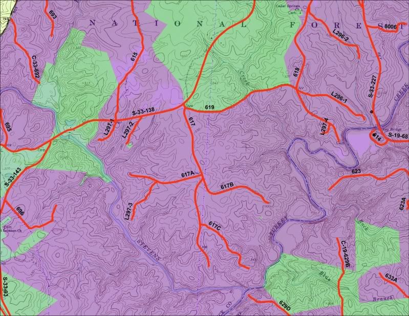
Is there a way to get from Turkey to the FS road (FS617 I think) that gets close (~300ft) to the trail near the mid way point? You can see it on the map HERE That'd give us a few shorter options. |
|
|
|
Post by wooglin on Aug 17, 2011 12:27:49 GMT -5
Now I gotta figure out just where the public land is exactly in terms of Mt Leb Church Rd. Check your email. Shapefiles of this info are on the Sumter NF site if anyone uses ArcGIS (follow the links from "Land Resources Management"). Quads are on the DNR site: www.dnr.sc.gov/pls/gisdata/download_data.login |
|
|
|
Post by dgaddis1 on Aug 17, 2011 12:50:54 GMT -5
Finding somwhere to stage this route could be an issue. Anyone have any ideas?
|
|
|
|
Post by seenvic on Aug 17, 2011 13:15:33 GMT -5
Now I gotta figure out just where the public land is exactly in terms of Mt Leb Church Rd. Check your email. Shapefiles of this info are on the Sumter NF site if anyone uses ArcGIS (follow the links from "Land Resources Management"). Quads are on the DNR site: www.dnr.sc.gov/pls/gisdata/download_data.loginHad nothing in email from you. Quads are not updated since the land changed hands in 2005 or so. Going to try my luck with the arcGis and see if I can import that stuff into my gps software. I don't have arcview or arcgis. |
|
|
|
Post by seenvic on Aug 17, 2011 13:18:06 GMT -5
Is there a way to get from Turkey to the FS road (FS617 I think) that gets close (~300ft) to the trail near the mid way point? You can see it on the map HERE That'd give us a few shorter options. You can get off Turkey Creek trail at that spot, no problem. We use that spot to access the trail for work. You can get off Turkey Creek at the 1 mile point( FS 618), the 3ish mile point (FS 617), the 5ish mile point (FS 617B) and of course at the very end onto 617A. |
|
|
|
Post by wooglin on Aug 17, 2011 13:37:13 GMT -5
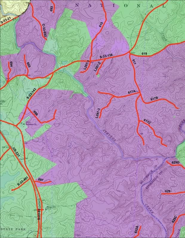
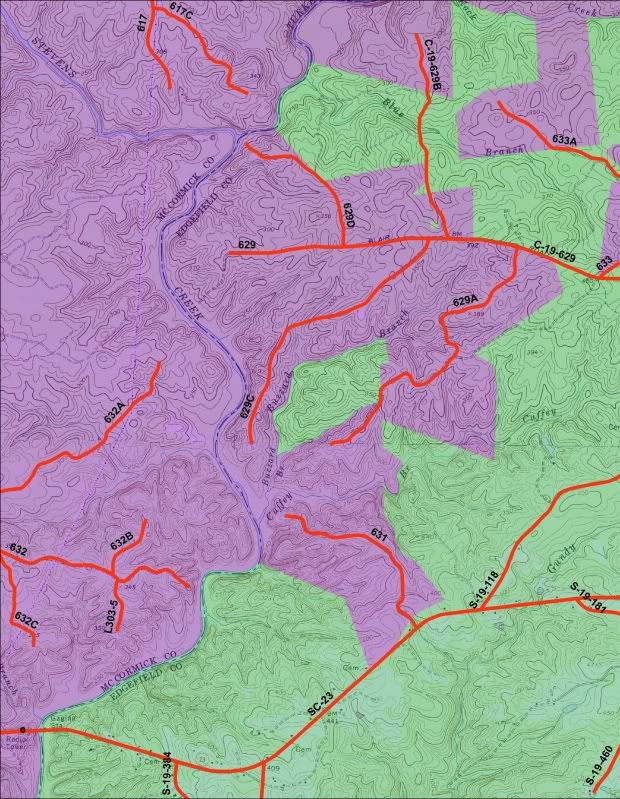
Had nothing in email from you. Quads are not updated since the land changed hands in 2005 or so. Going to try my luck with the arcGis and see if I can import that stuff into my gps software. I don't have arcview or arcgis. Purple is USFS land. Green is "other" (private). The data is dated March 2011. 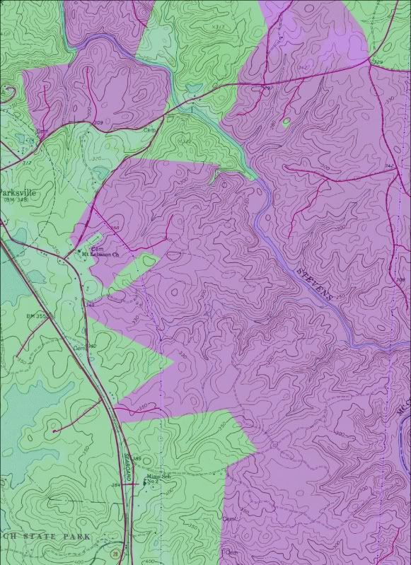 |
|
|
|
Post by dgaddis1 on Aug 17, 2011 13:56:05 GMT -5
You can get off Turkey Creek trail at that spot, no problem. We use that spot to access the trail for work. You can get off Turkey Creek at the 1 mile point( FS 618), the 3ish mile point (FS 617), the 5ish mile point (FS 617B) and of course at the very end onto 617A. That's what I thought. That'd give us 3 distance options, all lollipops, not including getting to/from north end of wine: 59.75 miles - route described above 45.10 miles - wine - turkey - pavel - modoc - pavel to 3 mile access point on Turkey - turkey - wine (27 miles of singletrack) 22.6 miles - wine - turkey - FS617A to FS-617 - turkey - wine (21 miles of singletrack) but where to stage the race from? |
|
|
|
Post by wooglin on Aug 17, 2011 14:21:48 GMT -5
|
|
|
|
Post by seenvic on Aug 17, 2011 14:22:20 GMT -5
Wondering if we can stage the race from a gravel road? FS 609.
Wondering if we can stage the race at Wine Creek TH? Small lot.
Nearby is FS 609. It is the one with the Christmas Tree Farm sign on it. The race could start on this gravel road, turn onto 283 for second and then into Wine Creek. It could end at Wine Creek.
Maybe not safe enough for parking/hanging out post race etc.....
Wooglin.....great map. Thanks. I hope that map is correct. If so, 85% of Old School Connector is on public lands. And the 15% not on public lands are right by Mt Leb Ch Rd, and according to this map, USFS property abuts that road. We may be golden.
|
|
|
|
Post by seenvic on Aug 17, 2011 14:25:52 GMT -5
Does 619 ever cross private? I rode it the other day and it appeared USFS has plowed a new road next to old 619 and it now a legal cut thru.
I notice the gravel roads we ride that make up the old school connector are not on there. This was private property until about 2005 and I suppose those old roads don't become FS roads automatically. That may a good thing, may be a bad thing.
|
|
|
|
Post by wooglin on Aug 17, 2011 14:30:18 GMT -5
|
|
|
|
Post by brianW on Aug 17, 2011 15:15:46 GMT -5
I am pretty sure that the Forest Service did plow a fire break along its border on fs 619. the signs I noticed were all on the north side of the road.
|
|
|
|
Post by DK on Aug 17, 2011 15:21:16 GMT -5
Does 619 ever cross private? I rode it the other day and it appeared USFS has plowed a new road next to old 619 and it now a legal cut thru. I notice the gravel roads we ride that make up the old school connector are not on there. This was private property until about 2005 and I suppose those old roads don't become FS roads automatically. That may a good thing, may be a bad thing. Here's the image from McCormick County GIS, private property is the yellow boundary. Click the pic for full size.  Link to the GIS is thinkopengis.mccormick.sc.wthtechnology.com/. Looks like 619 skirts the boundary of the private property going by this and wooglins map. |
|
|
|
Post by seenvic on Aug 17, 2011 15:53:33 GMT -5
The map Doug posted looks like their is a small sliver of private land b/n Mt Leb Church Road and the last set of powerlines on the old school connector. I know the private land owner who owns the land the old sch connector goes across, and he told he thought the route from powerlines to pavement crossed a sliver of private land....and I think he is right. Damn.
Wondering if we can make a route that skirts this private property. Hope so.
Edit to add: Well damn. The first map wooglin posted also shows the thin sliver of private land that messes up even the modified old school connector. gonna take some figuring out, I am afraid.
|
|
|
|
Post by Ted S. on Aug 18, 2011 17:26:02 GMT -5
If we could stage near the north end of wine, make a lollipop where you do the 'loop' twice: Wine - Turkey - Pavel - Modoc - 23/28/gravel - Modoc (again) - 23/28/pavel - Turkey - Wine = 59.75ish miles total, 37 single track, not sure how much pavement. Using the 'old school connector' would help. Add a few miles to get to and from Wine and it wouldn't be hard to reach that 62 mile (100km) goal. Shorter options are possible too. EDIT: this would avoid head on traffic, but it would also force the leaders to work their way thru traffic on their 2nd lap of the loop. Thoughts? This still works even with out the old school connector?? |
|