|
|
Post by dgaddis1 on May 31, 2010 5:31:41 GMT -5
Check it out, almost got the whole thing mapped now. Only thing I'm lacking is the connector from Keg out to the subdivision. I think the section on the road there is from the connector Dale built coming off Keg at Boulder Point. That route isn't legal anymore tho. Now you take a 4-wheeler path that comes out at a different cul-de-sac...can't remember which one though. Looks like mileage is going to come in at 66ish. What you see here is 65 miles. The distance scale on the map does't look right at all to me  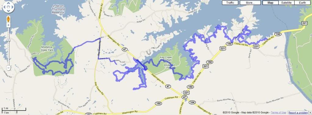 |
|
|
|
Post by brianW on May 31, 2010 6:52:24 GMT -5
I like the name "Thurmond Epic" Is that round trip or dam to Mistletoe?
|
|
|
|
Post by dgaddis1 on May 31, 2010 7:29:43 GMT -5
That's round trip, and includes Lake Springs both ways.
I'm hoping to get out and ride the whole thing in a few weeks. Looks like the 13th will be good as far as scheduling goes. Anyone else interested? That's a long trip to do solo.
|
|
|
|
Post by dsquaredmsquared on May 31, 2010 8:15:38 GMT -5
Don't know how slow you want to go but, if you need an 'average Joe' to gauge the distance/difficulty, I'd be up for giving it a try. Either way, I could loan you my GPS so you could map the whole ride with barometric altimeter etc.
|
|
|
|
Post by seenvic on May 31, 2010 8:18:25 GMT -5
Not so much interested in the whole thing. The route I plan to do is to park at Keg Creek, ride it and Mistletoe. Restock at car. Then ride one way to another car at West Dam. Will do everything once except the part b/n Mistletoe and Keg is done each way. The cars aren't very far apart so it makes for an easy shuttle to leave one at West Dam on the way to Keg Creek.
|
|
|
|
Post by dgaddis1 on May 31, 2010 8:22:33 GMT -5
Don't know how slow you want to go but, if you need an 'average Joe' to gauge the distance/difficulty, I'd be up for giving it a try. Either way, I could loan you my GPS so you could map the whole ride with barometric altimeter etc. You're in. I'll be going slow too. If it's cool with you, we can leave your car at Keg to resupply our packs, and it'll give you and me a bail out option if you want it. Bill - you could meet us at Keg...if you want to ride slow lol. Based on the gps info dsquared gave me, it looks like the whole thing has around 3200 ft of climbing. Not much at all for that kind of distance. Pedal pedal pedal pedal pedal pedal.... |
|
|
|
Post by brianW on May 31, 2010 11:12:51 GMT -5
I have been thinking of this ride. Do not know about dam to dam option or the one Bill suggested. If the back entrance to Keg is private land one could go up Washington Rd to Ridge (doesn't look that far)
I was also thinking car drop at the dam and than on car at the end of Ridge Rd.
|
|
|
|
Post by dgaddis1 on May 31, 2010 12:13:58 GMT -5
If the back entrance to Keg is private land one could go up Washington Rd to Ridge (doesn't look that far) There is a legal back way out of Keg. But instead of using the singletrack that Dale built, it's a climb up a rutted 4-wheeler path. Come with us on the 13th if you want. You could leave your car at Keg too. |
|
|
|
Post by dparrott on May 31, 2010 12:20:24 GMT -5
It really will be an Epic with all the trees down.
Why stop with Rock Dam/Cliatt in MSP? You can connect them all up to the very north end of the park.
|
|
|
|
Post by Ted S. on Jun 5, 2010 3:31:28 GMT -5
I think I would like to join you fellas if that's cool.I have ridden the dam to wild wood and back a few times but have never added the keg or mistletoe, It would be nice to have some show me where the connectors are.
|
|


