|
|
Post by jtaylor on Sept 6, 2009 21:26:38 GMT -5
Dale Parrott and I walked the trail today; cut numerous trees (we lost count) and used the hedge trimmer on the last 200 yards that needed trimming. There are a few spots of tall grass, but they are no problem (not stinging nettle). Trail is in good shape. Forgot how smooth the tread is and how nice the scenery is (on the 283 side). Creek crossing is very low water.
|
|
|
|
Post by dparrott on Sept 6, 2009 22:29:31 GMT -5
We cut so many trees that Jon's saw was literally smokin'!
|
|
|
|
Post by imnav8r on Sept 7, 2009 16:25:39 GMT -5
Thanks guys! Wine Creek is on my short list of trails to visit soon.
Bike Patrollers cutting trees!!! You make us proud!!!
|
|
|
|
Post by azdrawdy on Sept 7, 2009 17:42:32 GMT -5
Thanks for the mini work party. We look forward to getting back on the SMC-route trails this fall, once the spiders have thinned out.  JT: Noticed that you called Saturday. We were on the LCHT, and I was on one of those "Oh this is flowing soooo smoothly" parts and I couldn't make myself stop to answer the dad-blamed phone! Once I saw who called I thought you may be at HKSP. Obviously not! Thanks for the sweat. See you on the trails. MD |
|
|
|
Post by jtaylor on Sept 7, 2009 20:59:08 GMT -5
I rode Wine this morning to enjoy yesterday's hard work. Both creeks are very ride-able. What a sweet trail. Will plan this week's Thursday night ride for here.
|
|
|
|
Post by DavidT on Sept 8, 2009 4:45:48 GMT -5
What time Thursday night? Where will you meet? Key Bridge?
|
|
|
|
Post by EdgeE on Nov 2, 2009 15:53:35 GMT -5
10-31-09 Sat. AM ride - Started @ Price's Bottom and cleared a few limbs on the way out, 3 trees down, creeks crossings with flowing water - great ride!
|
|
|
|
Post by azdrawdy on Nov 2, 2009 20:20:07 GMT -5
Thanks for the update on Wine. Now that the spider count should be down, we'll be hitting Wine, Turkey and Modoc more frequently.
That said, let me know what weekend is good for you so we can set up a good mowing day for Horn. Sections 2 and 4.
MD
|
|
|
|
Post by azdrawdy on Nov 15, 2009 19:56:22 GMT -5
Tried to ride WC on Saturday. Did not get very far. The first bridge you come to (from the Price's Bottom parking lot) was knocked askew, and there were masses of debris blocking the trail so we abandoned the ride at about mile 1. Too wet, too mucky, too slippery and generally unrideable. Turned around and headed out to ride Turkey. To read more, see Turkey.  MD |
|
|
|
Post by tzeaser on Feb 21, 2010 7:55:36 GMT -5
Rode WC yesterday. The trail surface was good, but the middle section of the trail was in bad shape. Many trees down and privet hanging across the trail. A bridge at about the half-way point is gone and crossing the ravine on foot is trecherous.
|
|
|
|
Post by azdrawdy on Feb 21, 2010 8:37:34 GMT -5
Thanks for the update. That's pretty much exactly what we expect. It always takes one or two work parties per year to keep Wine rideable. There's been several above flood stage rains this past 12 months, and that floats the debris onto the trail in the center section.
MD
|
|
|
|
Post by brianW on Feb 21, 2010 13:56:11 GMT -5
price's bottom lot? is that the same as Key Bridge or is it from the 283 side? thanks -brianW
|
|
|
|
Post by dgaddis1 on Feb 21, 2010 18:20:53 GMT -5
Prices bottom is the parking lot at Key Bridge, on Key Rd.
|
|
|
|
Post by ted on Feb 21, 2010 19:31:31 GMT -5
maps.google.com/maps?f=q&source=s_q&hl=en&geocode=&q=yahoo+maps&sll=33.792679,-82.143509&sspn=0.002572,0.005638&ie=UTF8&hq=yahoo&hnear=&ll=33.793093,-82.143059&spn=0,359.954896&t=p&z=15&layer=c&cbll=33.793045,-82.142954&panoid=bqpMtkuELzLIChuqM7krsQ&cbp=12,289.76,,0,14.23 If you click on this link it will give you a visual of what the FS road looks like just up the road from the bridge going over the creek. Zoom out one time to see an aerial view.
|
|
|
|
Post by Timothyjames on Mar 6, 2010 14:38:22 GMT -5
didn't go, gonna check it out hopefully this weekend instead.
|
|
|
|
Post by EdgeE on Mar 16, 2010 8:07:29 GMT -5
Quick ride last night - Started @ 283 & only made it to the "Big Gully" (with the reroute through the gully & away from the washed out trail over Turkey - the bridge was abandoned years ago). The trail was in good shape & when I left there was only one tree to go under & one to go over.
The sections of the trail along Wine Creek are in great shape, however once the trail moves down onto the Turkey Creek flood plane it worsens. How hard would it be to get the lower sections rerouted to higher ground where possible?
Most of the small bridges & sections of boardwalk have been pushed around by flooding, and some are now across the trail. Someone has placed (not anchored) planks to create ramps up & over. I stopped & checked them out before riding over, and now I fell like I should have dismantled them. They did shift as I rode over, but held for my out & back - Any thoughts?
|
|
|
|
Post by Timothyjames on Mar 19, 2010 10:10:53 GMT -5
Taking a group of 3 out here today at 240ish and i'll try to snap some pics to show the situation!
|
|
|
|
Post by wooglin on Apr 2, 2010 18:01:24 GMT -5
The first 2 miles heading north from Key Bridge are the worst. Beyond the 5+ trees that are down in that section, the first bridge has been moved, but is still there. Might be able to winch it back into place, or dismantle it and rebuild it. This is looking back south. Its walkable as it is, but I wouldn't ride it. 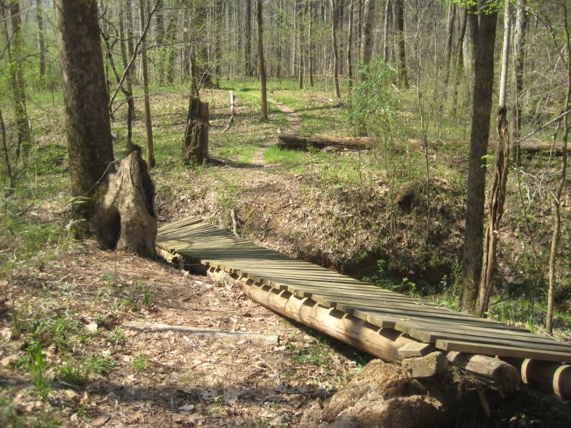 The last bridge in the first 2 miles is flat out gone, about 40 ft downstream. I don't think there's much that can be done about it aside from starting over. Where it crossed is a deep gully that you've got to scramble through. It's a b!tch with a bike. 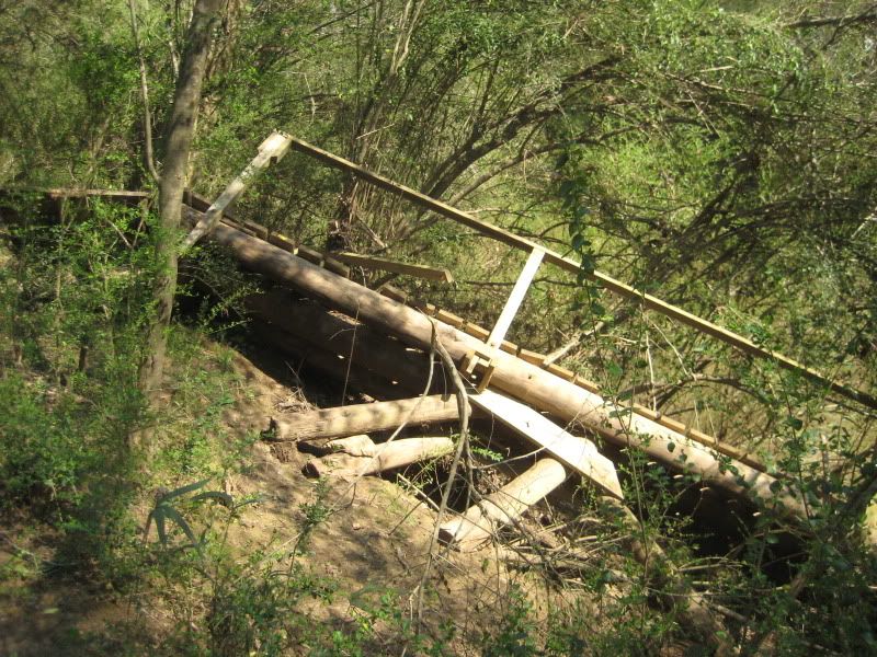 After that there's only minimal issues. Maybe one tree that will need a sawyer and one or two more that a handsaw can take care of. |
|
|
|
Post by seenvic on Apr 2, 2010 18:22:31 GMT -5
So this is the adventure ride option for the Summit?
Or y'all wanna clean it up?
|
|
|
|
Post by EdgeE on Apr 29, 2010 13:26:07 GMT -5
So this is the adventure ride option for the Summit? Or y'all wanna clean it up? Missed the last couple of meetings, any idea what we are going to do with this trail? |
|


