|
|
Post by seenvic on Jan 15, 2011 10:13:24 GMT -5
The red part is the section of Turkey Creek from Key Bridge to the dirt road (fs 618) I am assuming the possible "trespass" section is after you cross Coon Creek on FS 619. The road is gated off just before the creek. Looks like a NFS gate but just before 618 there is another gate that does not look like one. This is going ccw on Bill's map. After the creek the road branches. I took the going to the left. The one going to the right looked more like a new plowed fire break. I did Turkey last year and than looped around using FS 617, 619 and 618. Great ride. I refer to it as the Turkey Drum Stick. I did not see any signs. However it doesn't mean I was not on private land. Red is TC from Key Rd to just after you cross the first bridge. The trail swings left, and you exit the trail to the right and get on a dirt road/clearing. You take this across 618 and then the trespass is after you cross the FS 618 to the creek crossing. This is if you are going CW. I'd go CCW to keep your feet from getting wet until mile 30. You exit TC before you get to the broken boy scout bridge. You hit the first gravel road in a different place than if riding the trail only. |
|
|
|
Post by kconner on Jan 15, 2011 17:22:44 GMT -5
after looking at the GIS website for McCormick County, it seems that the "trespass" section follows the border between private land and forest land.....
|
|
|
|
Post by seenvic on Jan 17, 2011 9:04:58 GMT -5
I went out on the cross bike yesterday. Got started about noon. I parked on FS 617 near Price Mill Rd, on the west side of the creek crossing and decided I'd ride the loop CW and have the creek at the end of the ride.
The gravel roads were soft for the most part. Every once in a while an extremely sunny spot would be dry and fast. Every once in a while an extremely shady spot would be ice from edge to edge. Some of these spots were like singletrack....you'd have a 8" tire track to stay in with a 1-2" raised ice surface on both sides of you. It was sorta technical gravel riding in those spots.
Much of the gravel was just wet and soft. I got soaked from the knees down. I ended up missing a turn and getting on hwy 378....sorta lost for the first time in years. I knew generally where I was, but wasn't sure which road would take me where I needed to be. The fist one I tried didn't say dead end, but did dead end at what was a potential meth lab. I turned around, quickly. I ended up taking a right onto Gilchrist Rd, which I knew I was supposed to cross on my intended route. I found the crossing and decided to stay on Gilchrist and keep figuring out another way back to the car. I had gotten pretty wet from the knees down on the gravel, and the time spent riding the pavement had dried me out pretty good. I wasn't looking to get wet again and took a paved route back to the car and skipped the creek crossing.
This is a great route. It is really good on a cross bike, but would be fine on a MTB as well. Great time of year to have good site lines into the barren woods....and they are pretty this time of year.
I ended up with about 28 miles in just a hair over 2 hours on the bike.
I'd like to do this again on the cross bike soon. And not miss the turn this time.
|
|
|
|
Post by kconner on Nov 21, 2014 21:10:23 GMT -5
Rode this route today: 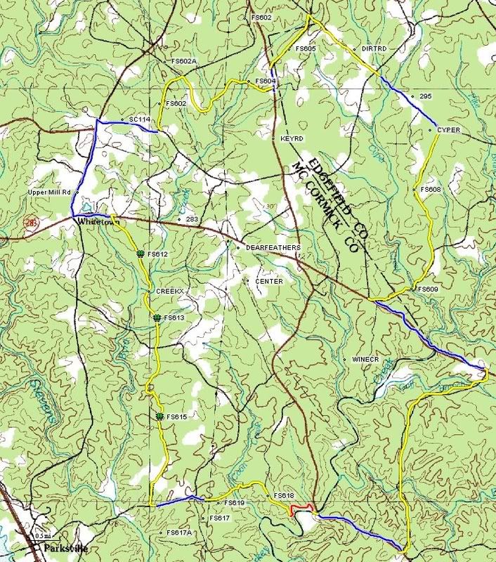 Good loop of mostly gravel around the Turkey Creek / Wine Creek area. Perhaps a few hundred yards of trespassing in the FS 618 area. If you ride this loop and start at Key Bridge, I'd ride it CCW. There is a creek crossing at the end of FS 619 in which you will get your feet wet. If you go CCW, you will do this with 2 miles to go. If you go CW, you will do this with 30 miles to go. The creek crossing on FS 612, 613 is a hike a bike. You should stay dry there. Red is singletrack, yellow is gravel and blue is pavement. Great route if you're looking to get some miles in with a couple of decent climbs. About 99% of the route is well marked and ridable right now, with only a couple of missing road signs. There has also been some logging activity along FS 612 and the path leading to the creek crossing is hard to see if you don't know where it is. Other than that, this route perfect! |
|