swest
Gear Masher

Posts: 13
|
Post by swest on Dec 28, 2010 15:10:43 GMT -5
I'm sure this has probably been addressed before but I couldn't find it. Which trails in the CSRA are solid and can take some winter bike traffic and which ones should be avoided? I understand FATS, New Bartram and probably Old Bartram are no-gos when it's wet but surely some of the other trails would be OK? And which ones? Between holiday preparations and the timing of the wet weather recently, I haven't been able to ride in a month  . And now there's rain in the forcast for this weekend as well. Please help me figure out which trails I can ride this weekend even if it does rain so I won't go completely stir crazy! |
|
Homer
Gear Masher
Posts: 47
|
Post by Homer on Dec 28, 2010 19:21:58 GMT -5
Your best bet is probably going to be Wine or Turkey. Those are some of the oldest most established trails in the area and probably need some love this time of year.
|
|
|
|
Post by Mark Y on Dec 28, 2010 21:38:35 GMT -5
I hear Boyd Pond doesn't hold water either. Only a couple of wet weather spots on Hickory Knob as I recall.
|
|
|
|
Post by brianW on Dec 28, 2010 21:50:06 GMT -5
Keg holds up well. Old Bartram tends to hold up well also.
|
|
swest
Gear Masher
Posts: 13
|
Post by swest on Dec 29, 2010 7:16:48 GMT -5
I rode Old Bartram not long after it rained once this fall (Possible the only time it rained this fall!) and it was pretty mushy in a couple of places so I thought that might be a problem. Or is that really what I should expect on most of them and it's not really going to tear up the trail if it's just in a few low spots?
I'm pretty new at this, I'm trying to figure out what to expect. Thanks for the help.
|
|
|
|
Post by dgaddis1 on Dec 29, 2010 8:04:47 GMT -5
Don't forget all the gravel roads in Sumter National Forest. Lotsa miles, some good climbs, and you can ride them any time you want.
|
|
|
|
Post by Mark Y on Dec 29, 2010 15:12:00 GMT -5
Don't forget all the gravel roads in Sumter National Forest. Lotsa miles, some good climbs, and you can ride them any time you want. Do any of you have a good map of those that shows all of the interconnections and so on? |
|
swest
Gear Masher
Posts: 13
|
Post by swest on Dec 29, 2010 15:27:01 GMT -5
"Do any of you have a good map of those that shows all of the interconnections and so on?"
Yeah, that was going to be my next question. This sounds like a good option but I'm not really familiar with the backroads. Are we talking forestry service roads here? Are they closed to motorized traffic? I'd be riding a grey bike possibly in the rain, I'm not really interested in becoming a hood ornament.
|
|
|
|
Post by dgaddis1 on Dec 29, 2010 15:34:28 GMT -5
Here's a link to a PDF of the official USFS Motor Vehicle Use map for the Long Cane district of Sumter National Forest. www.fs.fed.us/r8/fms/sumter/maps/documents/MVUM2010_LC.pdfThese are not closed to traffic, but they don't get much use. High visability clothing is good, as is a blinking tail light. Also, for traffic free riding, don't forget about the Palmetto Parkway bike path. It's got some good climbs. It's kinda short at just under 5 miles one way, but ride it a few times and you'll get a work out. You can ride as fast as you want too, unlike the Greenway. |
|
swest
Gear Masher
Posts: 13
|
Post by swest on Dec 29, 2010 16:09:27 GMT -5
Thanks for the map and the advice.  |
|
|
|
Post by Mark Y on Dec 29, 2010 20:57:10 GMT -5
Here's a link to a PDF of the official USFS Motor Vehicle Use map for the Long Cane district of Sumter National Forest. www.fs.fed.us/r8/fms/sumter/maps/documents/MVUM2010_LC.pdfThese are not closed to traffic, but they don't get much use. High visability clothing is good, as is a blinking tail light. Also, for traffic free riding, don't forget about the Palmetto Parkway bike path. It's got some good climbs. It's kinda short at just under 5 miles one way, but ride it a few times and you'll get a work out. You can ride as fast as you want too, unlike the Greenway. Cool Beans man! Just what I needed. |
|
|
|
Post by kingjr9 on Dec 29, 2010 21:49:37 GMT -5
bartram trail always seems to hold up well in my opinion not sure on the others rode turkey creek once after a shower i wont do that again though
|
|
|
|
Post by breynolds on Dec 30, 2010 17:32:56 GMT -5
Just rode the new section of Bartram from Petersburg out to Washington Road and back. Trail was in great shape, I think only 2 small mud puddles if I remember (the big red clay gully near mile marker 11 was one). The spots that are armored with those black plastic railway ties are bone dry, I couldn't believe how well that worked!
|
|
|
|
Post by Angela on Dec 30, 2010 19:34:55 GMT -5
The old section of Bartram Lake Trail is in great shape as well between Petersburg and West Dam. There is a tree down just before the gravel road you ride up and another before the Sailing Club Road crossing and still another just before the end at West Dam - they are significant enough that most would not consider them riders but the trail itself is in great shape and perfect riding condition at least until the rain comes on Saturday!
|
|
|
|
Post by brianW on Dec 31, 2010 9:55:26 GMT -5
just got back from an early morning (6am start) ride of Bartram. Only wet spot was that "hydrant" run off on Lake Springs Loop. Rest of the trail was bone dry.
as mentioned 3 trees down. 1. 50 ft from the dirt road (on the way to the air strip) 2. between West Dam and Sail Club road (if the tree was 10 ft taller it would of struck the concrete block building on top of the hill) 3. West Dam @ the short spur path that leads to the picnic area.
|
|
|
|
Post by dparrott on Jan 8, 2011 20:26:48 GMT -5
The 3 trees that Angela and Brian mention are cut. Actually, the one near the airstrip was already out of the way and I met the older couple who was responsible. They are regular runners on the Bartram and usually carry a small saw or clippers. They trim as they go. It's great that trail users other than MTBers help out. I only rode West Dam to the air strip but it was bone dry even after the rain we got last evening.
|
|
|
|
Post by Angela on Jan 9, 2011 19:57:29 GMT -5
Saw Dale this morning and he reported on the Bartram Lake Trail being dry we zipped up there to get a late afternoon ride in - went out about 5 miles on the new Bartram - trail was in fantastic shape and we had a great ride! Yesterday we felt sure the Friday rain had nixed any trail riding for the weekend so on Saturday we opted for what we call the Dogma ride - we parked just off Evans to Lock Rd near Blue Ridge in a little strip shopping center - rode from there down to the Savannah Rapids Pavilion and down the Augusta Canal Towpath just to get the exercise - not for everyone but you can get a decent ride in and if you go all the way to Broad and back you can pick up just under 20 miles. |
|
|
|
Post by seenvic on Jan 14, 2011 13:34:22 GMT -5
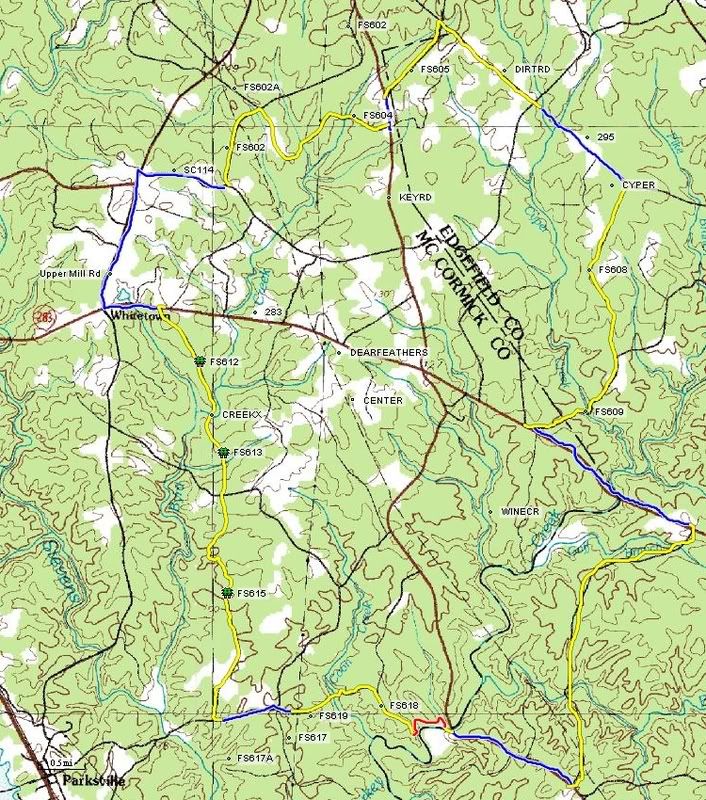 Good loop of mostly gravel around the Turkey Creek / Wine Creek area. Perhaps a few hundred yards of trespassing in the FS 618 area. If you ride this loop and start at Key Bridge, I'd ride it CCW. There is a creek crossing at the end of FS 619 in which you will get your feet wet. If you go CCW, you will do this with 2 miles to go. If you go CW, you will do this with 30 miles to go. The creek crossing on FS 612, 613 is a hike a bike. You should stay dry there. Red is singletrack, yellow is gravel and blue is pavement. |
|
|
|
Post by kconner on Jan 14, 2011 18:34:17 GMT -5
seenvic,
i'm assuming the red section is the part where one might be trespassing? also, how well is the singletrack marked and how much change in elevation are we looking at for the whole route?
|
|
|
|
Post by brianW on Jan 15, 2011 6:37:21 GMT -5
The red part is the section of Turkey Creek from Key Bridge to the dirt road (fs 618) I am assuming the possible "trespass" section is after you cross Coon Creek on FS 619. The road is gated off just before the creek. Looks like a NFS gate but just before 618 there is another gate that does not look like one. This is going ccw on Bill's map.
After the creek the road branches. I took the going to the left. The one going to the right looked more like a new plowed fire break.
I did Turkey last year and than looped around using FS 617, 619 and 618. Great ride. I refer to it as the Turkey Drum Stick. I did not see any signs. However it doesn't mean I was not on private land.
|
|

 . And now there's rain in the forcast for this weekend as well. Please help me figure out which trails I can ride this weekend even if it does rain so I won't go completely stir crazy!