|
|
Post by seenvic on Jun 10, 2008 9:44:25 GMT -5
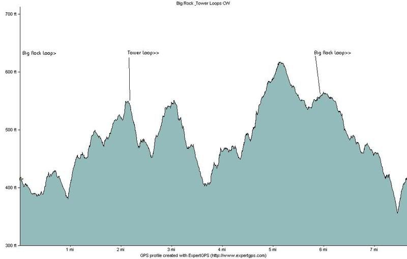 Above is the profile I made riding Big Rock & Tower Loops, both CW. It starts at the bottom of Big Rock, goes to the Tower connection, a full CW loop of the Tower, back to Big Rock to finish a CW loop of Big Rock. Seemed like a lot of climbing on dry, hot day. I got home with a mild case of feeling bad from it being so hot. Oh yea, there is another 160 feet of elevation gain riding up FS 661 to get to the bottom of the loops. I'd give the loops 2 thumbs up. Narrower corridor, bigger climbs/descents, some cool big rocks to ride on and near. It feels different from the old FATS. I would say Deep Step, Big Rock and Tower make for a heck of a ride. Then stop back at the car, reload the water and food and do the other three loops. You will know you went on a bike ride for sure. |
|
|
|
Post by dgaddis1 on Jun 10, 2008 10:09:46 GMT -5
That 200' climb on Tower (starting @ 3.75 miles on the profile above) is where I was cursing at Bill. It felt really steep.
Should make for a great work out though!
Bill, do you know how much climbing there is total w/both loops? And if you have it, each looop by it's self as well.
Have you ridden them on your SS yet?
|
|
|
|
Post by seenvic on Jun 10, 2008 10:23:48 GMT -5
I think there is about 350 on each loop for about 700 total. But my gut tells me more on the Tower Loop than on Big Rock.
I think I have ridden them on my SS. I keep a log at home of my rides and which bike I rode that day. I'll look. But i think I did them on the SS one day before the Tower was complete. I would think it would be tough, but rideable on the SS.
I came away thinking CW was the tougher direction on the Tower Loop. I think CW is my prefered direction on the Big Rock.
I'll add that i just love the cedar log bridge on Big Rock Loop.
|
|
|
|
Post by seenvic on Jun 10, 2008 10:29:03 GMT -5
That 200' climb on Tower (starting @ 3.75 miles on the profile above) is where I was cursing at Bill. It felt really steep. ? What I like about these climbs is that you can't always see the top from the bottom, or from near the bottom. Most climbs around here you get a visual on the top pretty quick into the climb. On some of these climbs, when you get to what you thought was the top, you still got more climbing to do. And I think there are even a few with more than one "false top". And this is what makes these climbs great and have an almost mountain like feel to them. Not bad for a trail that sits below 600 feet above sea level for most of the route. |
|
|
|
Post by dgaddis1 on Jun 10, 2008 11:52:57 GMT -5
Yeah, the cedar log bridge is very cool. I do think CW is the toughest route on Tower, though I haven't ridden it CCW yet. And, that way you'll be going down the switchbacks instead of climbing up them.
And they are doable on a single speed...I rode almost every inch, all but the last bit of the big climb on Tower. At that point the heat got to me, and I committed the unspeakable act of walking up the last part of the hill. But, if I can (almost) do it, then there's lots of folks that can!
I want to hit the "ramp rock" on Big Rock (you know the one, near the northern road crossing on the east side...you can use it as a kicker going CCW). But I'm concerned about landing on almost flat ground (from about 4' in the air), and hitting that tree. I will try it one day though. (that'd be a good place for an alternate "advanced" line btw)
|
|
|
|
Post by seenvic on Jun 10, 2008 11:59:07 GMT -5
I want to hit the "ramp rock" on Big Rock (you know the one...you can use it as a kicker going CCW). But I'm concerned about landing on almost flat ground (from about 4' in the air), and hitting that tree. I will try it one day though. (that'd be a good place for an alternate line btw) Show me the spot sometime. We are still in the constuction phase. We can build it if it is buildable with hand tools. I don't run the machines and would struggle to get someone here who can for something like this. |
|
ec494
Gear Masher

Posts: 46
|
Post by ec494 on Jun 10, 2008 12:10:37 GMT -5
Two new loops, this is exciting. How long are the loops and is there a trail map?
|
|
|
|
Post by dgaddis1 on Jun 10, 2008 12:15:47 GMT -5
|
|
ec494
Gear Masher
Posts: 46
|
Post by ec494 on Jun 10, 2008 12:35:28 GMT -5
Where is philpot rd in relation to FATS?
|
|
|
|
Post by dgaddis1 on Jun 10, 2008 12:47:48 GMT -5
Everyone calls it Philpot Rd, but I haven't seen any signs that say Philpot on them. It's FS road 661, west of FATS. It connects to Woodlawn Rd at it's northern end, and Deep Step Rd. at it's southern end.
|
|
ec494
Gear Masher
Posts: 46
|
Post by ec494 on Jun 10, 2008 12:51:59 GMT -5
So 8/10ths of a mile up FS661 is access to Big Rock the Big Rock takes you to Tower? Are they independent loops How long is Big Rock? Thanks
|
|
|
|
Post by dgaddis1 on Jun 10, 2008 13:20:25 GMT -5
Yes, FS661 takes you to Big Rock. Each loop is independant, there's a connector between the two. Tower is all on the west side of FS661. Big Rock crosses FS661 twice. The connector is near where Big Rock crosses FS661 at the northern end. IIRC, my computer showed Big Rock being 4.2 miles.
|
|
|
|
Post by seenvic on Jun 10, 2008 13:51:52 GMT -5
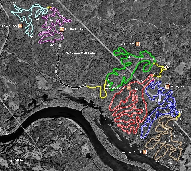 OK, here is a map. I should have posted this the first time. There is a sign at the top of FS 661 that says Philpot Rd. It is both FS 661 and Philpot Rd. Big Rock and Tower are each about 4 miles. I rode from the main parking lot to Deep Step CCW. I rode the new connector for the first time and then up the pavement and gravel to Big Rock Loop. At about the 2 mile point of Big Rock, you come to the intersection that takes you over to the Tower Loop. I rode this to Tower, and one CW loop of Tower. Rode the same short connector to Big Rock and finished the Big Rock Loop. That is why the profile is Big Rock > Tower > Big Rock. |
|
ec494
Gear Masher
Posts: 46
|
Post by ec494 on Jun 10, 2008 13:55:54 GMT -5
Thank you, I am looking forward to heading out there.
|
|
|
|
Post by dgaddis1 on Jun 10, 2008 14:41:25 GMT -5
You know, there sure is a lot of "unused" space between Big Rock and Deep Step  |
|
|
|
Post by azdrawdy on Jun 10, 2008 15:49:50 GMT -5
You know, there sure is a lot of "unused" space between Big Rock and Deep Step LMAO!!!!! |
|
ec494
Gear Masher
Posts: 46
|
Post by ec494 on Jun 10, 2008 22:50:39 GMT -5
With the sporadic storms are the new loops ok to ridefor wed am?
|
|
|
|
Post by ted on Jun 11, 2008 7:23:01 GMT -5
A rule of thumb is allow 24 hours for rain to soak in the current trails.
After last nights rain, I'd say the old loops should be fine (use your best judgment when you hit the trail).
The new ones need "AT LEAST" 24 hours after the amount we had last night and will probably be best Thurs am.
Most of the new loops are still soft and if ridden while wet will cause ruts that are hard to repair after the soil dries.
Ideally when the rain falls, it soaks into the ground and settles which is great. The problem comes when the trail is ridden while still wet, even slightly wet.
I'm going to walk the new trails this morning to clean up and see exactly what the tread looks like at this point after rain. I'll report back on their conditions early this afternoon.
|
|
|
|
Post by seenvic on Jun 11, 2008 9:33:56 GMT -5
I was at FATS Monday night. I drove past the main parking lot and it was a sunny, dry and hot 97degrees. A mile down the road, the pavement was wet. A few hundreds yards further and the entire area was soaking wet. It was 76 degrees on the same themometer.
I got home a few minutes later, about 2 miles from main parking lot. It was still hot and dry at home.
|
|
|
|
Post by ted on Jun 11, 2008 11:00:01 GMT -5
They're fine.
|
|


